Council Greenlights Plan to Safeguard Maspalomas
The Government Council of the Gran Canaria Island Council, at the request of the Minister for Territorial Policy and Landscape, Inés Miranda, has this Thursday given the green light to the proposal to begin drafting the Natural Resource Management Plan for the Maspalomas Dunes (C-7). This move aims to secure the future of the site by ensuring the necessary conditions for its conservation are maintained, as highlighted by the island corporation in a statement.
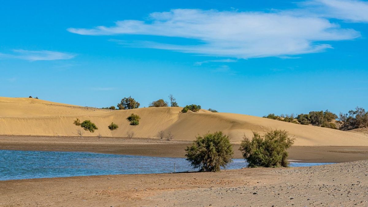
A Protected Landscape of Nearly 404 Hectares
The area earmarked for protection covers almost 404 hectares located on an alluvial plain at the southern tip of Gran Canaria, within the municipality of San Bartolomé de Tirajana. It is bordered to the north by the tourist resorts of Playa del Inglés and Campo de Golf, to the west by the El Oasis and Campo Internacional urbanisations, and to the south and east by the 6-kilometre-long stretch corresponding to the beaches of Playa del Inglés and Maspalomas.
It is important to note that, with the exception of the palm grove area, the scope of this Natural Reserve is included within the public maritime-terrestrial domain. It is primarily defined by the Dune Field, the Maspalomas Pond, the Oasis Palm Grove, and the Tony Gallardo Park.
The Unique Ecosystems Within the Reserve
In detail, the Dune Field constitutes a habitat in motion, where sand circulates naturally thanks to the fragile equilibrium between the sand, the wind, and the sea currents. As a result, the dunes create a landscape of great beauty, which has become one of Gran Canaria’s main tourist attractions. Its conservation is vital because, besides supporting unique biodiversity, it forms an important natural barrier against coastal erosion and the effects of climate change.
Similarly, the Maspalomas Pond, located at the final stretch of the Maspalomas ravine, is a lagoon of brackish water. The vegetation growing both around and within it serves as a nesting site for native birds and a refuge for a great variety of migratory species, together forming a natural environment of high quality and scientific interest.
A comparable situation exists with the Oasis Palm Grove, situated west of the Maspalomas ravine, which is a remnant of the ancient Maspalomas oasis. This palm grove-tamarisk habitat is currently divided into two parts by the Avenida Touroperador Neckerman. Finally, in the northern part of this Palm Grove lies the fourth element of the Natural Reserve, the Tony Gallardo Park, which has recently been restored and prepared for public visits.
Balancing Protection With Human Activity
In the words of Inés Miranda, the Maspalomas Dunes Special Natural Reserve is an emblematic and identity-defining place for Gran Canaria and, therefore, must have a planning instrument that allows for its greater protection while ensuring compatibility with any uses that may occur within it. She stated it is “an area that supports a very diverse and unique biodiversity on the planet,” hence the need to “conserve that natural protection which the Dunes provide, which, at the same time, protect us and act as a natural barrier against coastal erosion and the adversity of climate change.”
The minister also emphasised that the reserve currently suffers significant impact from human activities related both to recreational beach uses and the denaturalisation of its surroundings due to the occupation of tourist urbanisations. These circumstances make it vitally important to ensure its protection and reconcile the type and intensity of uses it hosts with the conservation of its natural values.
“Obviously, a series of human activities take place in that area which inevitably cause a certain degree of deterioration,” Miranda acknowledged. “We want to enhance the value of the site and reconcile tourist use, the use by hikers in the area and regular bathers with the development of all that biodiversity of this natural space,” she asserted.
A Plan for the Future
In summary, the Cabildo de Gran Canaria, through the Ministry of Territorial Policy and Landscape, seeks greater protection for the Maspalomas Dunes while making it compatible with human uses and preventing construction or human alteration from causing greater erosion in this highly valuable territory, “which puts Gran Canaria on the world map for tourism and development,” she concluded.
Thus, with these premises, the Natural Resource Management Plan for the Maspalomas Dunes is the specific instrument that will delimit and categorise this space to be protected for its natural values. It will identify the most significant elements of the territory’s natural heritage, establish the appropriate criteria to conserve it, and define the measures that will allow for the development of activities and uses compatible with its protection.

Canary Islands to get first dedicated biodiversity law

Tenerife seismic activity: 550 events recorded in 24 hours

Contigo La Palma slams ‘unethical’ banana aid compensation
Canary Islands observatories get major data network boost
Energy storage framework finally approved for Canary Islands

US military hub near Canaries: what it means for Spain
Man arrested after wildfire in Masca ravine spread near homes
Injured hiker airlifted from Güigüí

New indicator reveals sea temperature rise around Canary Islands