Yellow weather warnings across the Canary Islands
The State Meteorological Agency (Aemet) forecasts a slight rise in temperatures for this Saturday (6 June) in Tenerife, with thermometers potentially reaching 28°C. However, strong winds and adverse coastal conditions will continue to dominate the forecast. Indeed, the island will once again be under a yellow warning for both phenomena.
Wind and coastal hazards remain the focus
Across the archipelago as a whole, very strong northeasterly gusts are expected on mountain peaks and the northwestern and southeastern slopes of the mountainous islands, as well as in the afternoon on the southern flank of the Tenerife metropolitan area. Elsewhere, skies will be mostly clear or with little cloud, except for some cloudy intervals below 800-1,000 metres in the north of the islands during the early morning and after dusk. Temperatures will see little change, though there may be slight to moderate rises in maximums at mid-altitudes, with the possibility of locally reaching 30°C in mid-altitude areas and south-facing low-lying zones.
Detailed forecast for Tenerife and La Gomera
The Aemet forecast for the province of Tenerife, as reported by EFE, is as follows:
Tenerife: Mostly clear or with little cloud, except for some cloudy intervals below 900-1,100 metres in the northeast during the early morning and after dusk. Minimum temperatures will see little change. Maximums will rise at mid-altitudes, especially on south-facing slopes; elsewhere, little change or slight rises. The trade winds will be strong at times in the far west, in low-lying areas of the southeast, and in high-altitude areas on the western slopes, where very strong gusts are likely, as well as on the southern flank of the metropolitan area and the Las Cañadas area in the afternoon. Light breezes on the south and west coasts. Forecast minimum and maximum temperatures (°C): Santa Cruz de Tenerife 21 28.
Forecast for La Gomera
La Gomera: Mostly clear or with little cloud, except for some cloudy intervals below 800-1,000 metres in the north during the early morning and after dusk. Temperatures will see little change, except for slight rises in maximums in the south. The trade winds will generally be strong in exposed areas of the eastern and northwestern slopes and on peaks, where very strong gusts are expected, especially from afternoon onwards, possibly locally exceeding 80 km/h. Light breezes on the south coasts. Forecast minimum and maximum temperatures (°C): San Sebastián de La Gomera 20 26.
Forecast for La Palma
La Palma: Mostly clear or with little cloud, except for some cloudy intervals below 800-1,000 metres in the north and east during the early morning and after dusk. Minimum temperatures will see little change. Maximums will see moderate rises at mid-altitudes, with generally slight rises elsewhere. The trade winds will generally be strong in exposed areas of the southeastern and northwestern extremes, as well as on peaks and in the municipality of El Paso; in these latter areas, especially during the first part of the day. Light breezes on the west coasts. Forecast minimum and maximum temperatures (°C): Santa Cruz de La Palma 19 25.
Forecast for El Hierro
El Hierro: Mostly clear or with little cloud, except for some cloudy intervals below 700-900 metres in the north during the early morning and after dusk. Temperatures will see little change, except for slight rises in maximums in the south. The trade winds will be strong at times in exposed areas, especially in El Pinar, as well as on exposed peaks, where very strong gusts are likely. Light breezes on the southwest coasts. Forecast minimum and maximum temperatures (°C): Valverde 14 19.
What’s happening in the Canaries – straight to your phone
News, weather alerts and practical updates – direct from the islands, in English. We live here and know what’s going on – before the international media catch up. Everything lands on our WhatsApp channel – no middlemen, no algorithm. Curated for families, expats and travelers.

Heatwave alert: Gran Canaria faces high temperatures

Monday: calmer winds and patchy northern clouds

Tenerife science museum offers free glasses for August solar eclipse

Sunday: calmer winds and scattered clouds

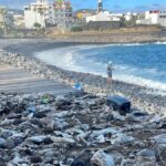
Playa Jardín hit by new contamination just weeks after reopening

Friday: calima haze and strong gusts for the Islands

Thursday: strong winds, calima and 37°C on Gran Canaria
Canary Islands heatwave: Temperatures to hit 37°C

Wednesday: stable alisios, calima, and strong gusts