
Compiled with the help of artificial intelligence, based on Spanish-language information. Source below the article.
Summer lingers on in the Canary Islands
Although August is drawing to a close and September is settling into the calendar, summer in the Canary Islands still has many weeks of warm weather ahead. That said, temperatures are already beginning to feel slightly lower than they were in July. This ninth month of the year is characterised by calmer winds and seas, with spring tides and water spilling over onto island shores, and a gentler heat than in previous months. However, while cold weather is still a long way off, September is expected to begin with some rain in parts of the archipelago. This is the forecast from the State Meteorological Agency (Aemet) for the final days of August.
Sunday: cloudy intervals in the north
In the north of the mountainous islands, cloudy intervals are expected with a low probability of weak and occasional showers in the northeast of La Palma and Tenerife. Elsewhere, skies will be mostly clear, with some cloud cover during the night in Lanzarote and Fuerteventura, and intervals of cloud development in Tenerife. Temperatures will see little change, with slight rises in minimum temperatures in inland areas of the islands with greater relief. Winds will be moderate from the northeast, with strong intervals on the southeast and northwest slopes of the mountainous islands. In the central peaks of Tenerife, a moderate southwest wind, occasionally strong, will shift to the west by the afternoon.
Monday: possible 30°C highs in the east
Monday will bring cloudy skies in the north of the islands, tending to become mostly clear in the more eastern islands during daylight hours. In the mountainous islands, clear spells are expected in those areas during the central hours of the day. Elsewhere, skies will be mostly clear or sunny. Temperatures will see little change. It is likely that 30°C could be reached in the far southeast of Lanzarote and Fuerteventura, on the mid-altitude southern and western slopes of Gran Canaria, and in low-lying areas south of the Tenerife metropolitan area. Winds will be moderate from the northeast with strong intervals on the slopes and at the southeast and northwest tips of the mountainous islands, where there is a low probability of very strong gusts. Sea breezes are expected on the south and southwest coasts of the islands with the greatest relief.
Tuesday: a dry start to September
Still with a degree of uncertainty, given how far ahead the forecast reaches, the European weather model (ECMWF) suggests that the first day of September, Tuesday, will be very similar to these final days of August, with northerly winds and practically clear skies, with no rain in sight during the first half of the day. However, cloud cover will increase by the afternoon, particularly over the central islands of the archipelago, which could bring some precipitation to the most mountainous areas of Tenerife and Gran Canaria.
Aemet’s forecast indicates cloudy intervals in the north of the islands with greater relief, giving way to mostly clear skies in the afternoon. Elsewhere, skies will be mostly clear or sunny. Minimum temperatures will see little change, while maximums will remain steady or rise slightly, especially in inland and southern areas. Winds will be moderate from the northeast, becoming strong on the southeast and northwest slopes of the mountainous islands, particularly from the afternoon onwards.
Wednesday: rain spreads across Tenerife
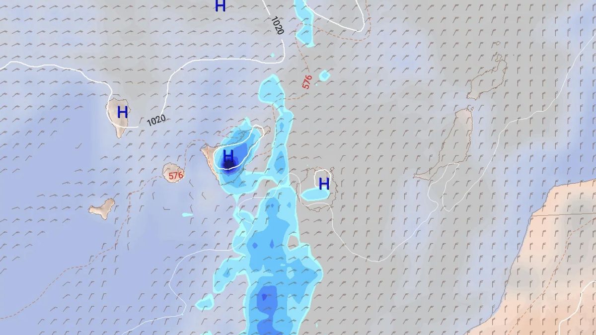
By Wednesday, this cloud cover will persist and increase as the day progresses, accompanied by winds still coming from the north and northeast. By mid-morning, according to the European model map, rain is expected across almost all of Tenerife, with the highest accumulations in the central area facing south, as well as in the central and western parts of Gran Canaria, although in smaller quantities. Aemet forecasts cloudy skies in the north of the islands, tending to intervals from midday onwards. Elsewhere, skies will be mostly clear. Temperatures will see little change or a slight drop in maximums in the most eastern islands. Winds will be moderate from the northeast, strong on the southeast and northwest slopes of the mountainous islands, where there is a low probability of very strong gusts.
Thursday and Friday: winds ease, rain lingers
On Thursday, cloud cover will persist in parts of the archipelago, with the possibility of rain, particularly on the island of Tenerife. The wind will continue to blow from the north, but with less intensity over the western islands. Looking ahead to Friday, the wind will continue to drop, as is customary at this time of year, and there will again be a chance of rain in Gran Canaria and Tenerife, especially in the latter, particularly in its central area and eastern slopes.
What’s happening in the Canaries – straight to your phone
News, weather alerts and practical updates – direct from the islands, in English. We live here and know what’s going on – before the international media catch up. Everything lands on our WhatsApp channel – no middlemen, no algorithm. Curated for families, expats and travelers.

Tuesday: heavy showers and storms in El Hierro

El Hierro issued yellow warning for heavy rain

Monday: autumn showers and a cooler feel

Sunday: scattered clouds and showers on the islands

Saturday: cooler air and clearing Saharan dust

Canary Islands weather: rain and storms on the way

Friday: summer heat before an autumnal weekend

Tuesday: cloud, showers and a building swell

Monday: cloud cover and scattered showers
