
Brief return of rain before sunny weekend
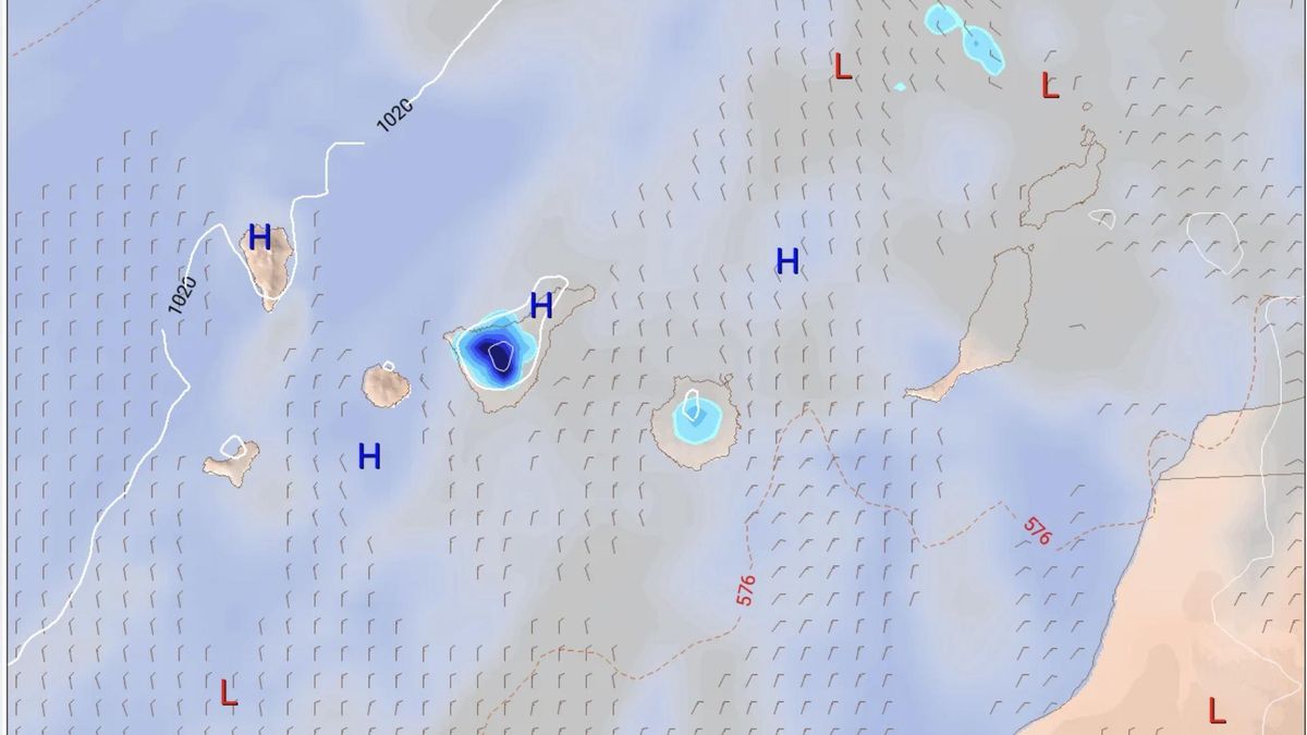
Although temperatures are reaching summertime levels, the Canary Islands may see rain again this week. It will be short-lived, however, as skies are expected to clear once more by the weekend. According to the European forecast model, Tuesday and Wednesday are the days when rain is expected on Tenerife, Gran Canaria and La Palma, and to a lesser extent, on El Hierro.
Here is the outlook from Spain’s State Meteorological Agency (Aemet) for the coming days in the Canary Islands:
Monday: heat warnings and light calima
As a notable weather phenomenon, Aemet reminds us that yellow heat warnings are in place on three islands: maximum temperatures could reach or locally exceed 34°C in inland and southern areas of Lanzarote and Fuerteventura, as well as on mid-altitude slopes and peaks facing south and west on Gran Canaria.
As for the forecast, skies will be mostly clear with some cloud intervals on northern coasts. There will be a light calima (dust haze) affecting the eastern province and Tenerife, being more noticeable towards the eastern part of the archipelago. Temperatures are rising, particularly the maximums on the mountainous islands. They will reach or exceed 34°C locally on Lanzarote and Fuerteventura, and on mid-altitude slopes and peaks facing south and west on Gran Canaria. There is a low probability that this threshold will also be reached on mid-altitude slopes in the north of that island, as well as on southern slopes of Tenerife and La Gomera. Wind will generally be light from the north-west on Lanzarote and Fuerteventura, stronger at the northern and southern extremes, and light from the north on the other islands, stronger on eastern and north-western slopes; shifting to southerly on mid-altitude slopes and higher areas.
Tuesday: more heat and rain arriving
As a notable weather phenomenon, Aemet notes that maximum temperatures could reach or locally exceed 34°C in inland and southern areas of Lanzarote and Fuerteventura, as well as on mid-altitude slopes and peaks facing south and west on Gran Canaria.
As for the forecast, intervals of medium and high cloud are expected, with predominance of low cloud on northern coasts at the beginning and end of the day. Light calima in the eastern islands and Tenerife. Minimum temperatures will rise on the mountainous islands, especially on mid-altitude slopes, and maximums will rise slightly, more noticeably on south and west-facing slopes of the eastern islands and Tenerife. Temperatures will exceed 34°C in inland areas of Lanzarote and Fuerteventura, and on south and west-facing slopes of Gran Canaria. It cannot be ruled out that this threshold could also be reached on southern slopes of Tenerife and La Gomera, and on mid-altitude slopes in the north of Gran Canaria and the metropolitan area of Tenerife. Wind will generally be light from the north-west on Lanzarote and Fuerteventura, occasionally strong at the northern and southern extremes, and light from the north on the other islands, stronger on eastern and north-western slopes; shifting to southerly on mid-altitude slopes and higher areas.
Wednesday: rain and temperatures drop
Generally mostly clear with some intervals on northern coasts at the beginning and end of the day. Temperatures will drop, and this could be locally significant for maximums in inland areas. Wind from the north shifting to westerly on mid-altitude slopes and peaks, according to Aemet.
The European forecast model shows rainfall over inland areas of Tenerife, especially on slopes facing south and east of the island.
Thursday: clearing skies and cooler conditions
Mostly clear with some intervals in the north at the beginning and end of the day. Temperatures will drop, and this could be locally notable on mid-altitude slopes and peaks. Wind from the north.
From Thursday onwards, though there is still some uncertainty given the lead time of the forecast, skies are expected to clear again and remain that way at least until the weekend. Temperatures are also expected to soften once more.
What’s happening in the Canaries – straight to your phone
News, weather alerts and practical updates – direct from the islands, in English. We live here and know what’s going on – before the international media catch up. Everything lands on our WhatsApp channel – no middlemen, no algorithm. Curated for families, expats and travelers.

Rain alert declared for El Hierro as La Palma stays on pre-alert

Wednesday: showers and unstable air across the Islands

Tuesday: heavy showers and storms in El Hierro

El Hierro issued yellow warning for heavy rain

Monday: autumn showers and a cooler feel

Sunday: scattered clouds and showers on the islands

Saturday: cooler air and clearing Saharan dust

Canary Islands weather: rain and storms on the way

Friday: summer heat before an autumnal weekend
