Compiled with the help of artificial intelligence, based on Spanish-language information. Source below the article.
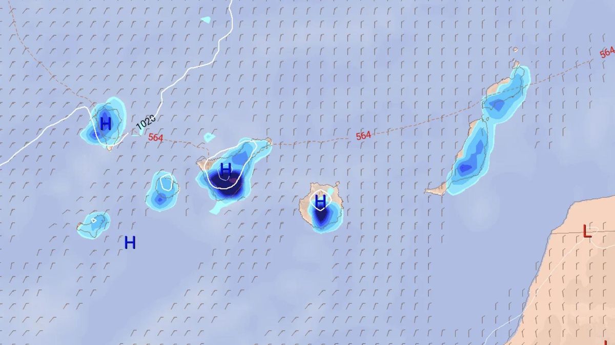
October has arrived in the Canary Islands with rain falling across every island, but particularly in Tenerife, La Palma, El Hierro and Gran Canaria. As the week goes on, showers will spread to the entire archipelago, with some accompanied by thunderstorms this Tuesday. Here is the State Meteorological Agency (Aemet) forecast for the coming days in the Canary Islands.
Tuesday
As a notable feature, Aemet warns of probable locally heavy showers in the interior of Tenerife, Gran Canaria and El Hierro. Occasional storms cannot be ruled out, especially in the eastern islands and in Tenerife during the afternoon. Light calima at high levels.
In its ordinary bulletin, Aemet indicates cloudy intervals in the mountainous islands, with cloudy skies predominating from the afternoon in inland areas, where occasional showers are likely. These could be locally heavy in the interior of Tenerife and Gran Canaria and, with lower probability, in El Hierro. In Lanzarote and Fuerteventura, cloudy intervals, especially of medium and high cloud, with a low probability of scattered rainfall.
Rainfall may be accompanied by occasional storms, mainly in the eastern province and Tenerife. Light calima at high levels, more significant in the mid-altitudes and summits of the central islands, as well as in Lanzarote and Fuerteventura. Temperatures will see little change overall, aside from slight to moderate drops in maximum values in inland areas. Light to moderate northeasterly wind, stronger on the southeastern and northwestern coasts in the afternoon, turning easterly at mid-altitudes and southerly on the summits.
Wednesday
As a notable feature, Aemet warns of a low probability of any locally heavy shower in inland areas and on the northern and eastern slopes of the mountainous islands. The forecast indicates cloudy intervals in the mountainous islands, with cloudy skies predominating in the north and, from the morning, also in inland areas and eastern slopes, where occasional showers are expected, especially during the morning and afternoon. These cannot be ruled out as being locally heavy or accompanied by an isolated storm.
Cloudy intervals in Lanzarote and Fuerteventura, with clearer skies opening up late in the afternoon and a low probability of some weak rain during the central hours of the day. Temperatures falling in inland areas, especially maximum values, with little change on the coasts. Moderate northeasterly wind, stronger on the southeastern and northwestern slopes of the mountainous islands; on the summits, light westerly wind.
Thursday
Cloudy intervals in general. Rain in the north of the mountainous islands, especially in the early and late hours; in the easternmost islands it will be less likely and generally weak, and in the remaining areas some occasional shower cannot be ruled out, especially in inland areas of the south and west during the afternoon. Temperatures with little change or a slight drop in minimum values. Moderate northeasterly wind, stronger on the southeastern and northwestern slopes of the mountainous islands in the afternoon.
Friday
Cloudy intervals in general. Rain in the north of the mountainous islands, especially in the early and late hours; in the easternmost islands it will be less likely and generally weak, and in the remaining areas some occasional shower cannot be ruled out, especially in inland areas of the south during the afternoon. Temperatures with little change. Moderate northeasterly wind, stronger on the southeastern and northwestern slopes of the mountainous islands, turning northerly on the summits.
What’s happening in the Canaries – straight to your phone
News, weather alerts and practical updates – direct from the islands, in English. We live here and know what’s going on – before the international media catch up. Everything lands on our WhatsApp channel – no middlemen, no algorithm. Curated for families, expats and travelers.

Monday: cloud cover and scattered showers

Canary Islands rain pre-alert lifted after wet weekend

Sunday: scattered clouds and light showers

Rain pre-alert issued for Lanzarote, Fuerteventura and more
Playa Jardín in Puerto de la Cruz reopens after water quality tests
Saturday: showers and rough northern seas
Lanzarote yellow warning for heavy rain this weekend
Canary Islands record hottest September since 1961

Wednesday: scattered showers and cooler air