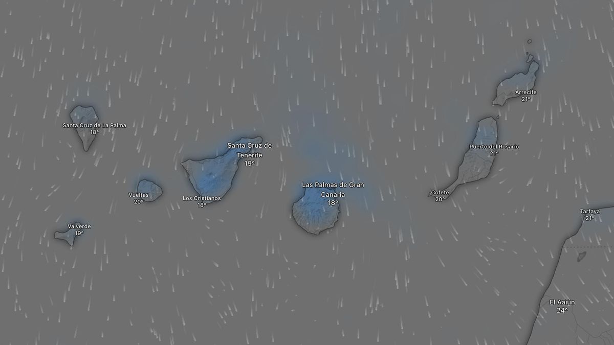
Light rain set to continue across the Canary Islands, but no storms in sight
Rain seems to have taken a liking to the Canary Islands and, for now, shows no sign of leaving the archipelago’s skies. However, according to the State Meteorological Agency (Aemet), no storms are on the horizon; only light precipitation is expected in the north of the islands with more pronounced terrain. Temperatures will see few changes, and the wind will continue to blow from the north or north-east, meaning no calima intrusion is forecast for the coming days.
Sunday: Cloudy intervals and light rain in the north
Sunday will see variable cloud cover, becoming mostly cloudy, with likely light rain in the north, especially during the early hours and the final hours of the day. There is a lower chance of rain in the interior areas of the mountainous islands around midday and in the afternoon. The probability of precipitation is low in the easternmost islands. Temperatures will see few changes. Moderate north winds will prevail, with north-easterly winds dominating in the westernmost islands.
Monday: Occasional light showers, mainly in the north
Monday will bring variable cloud cover, becoming mostly cloudy, with a low probability of occasional light rain in the north of the islands. Temperatures will remain largely unchanged. Moderate north winds are expected in the western islands, and north-westerly winds in the eastern ones.
Tuesday: Night-time and afternoon showers in mountainous areas
Tuesday will see variable cloud cover, becoming mostly cloudy, with a low probability of occasional light rain in the north of the mountainous islands during the night-time hours, and in interior areas around midday and in the afternoon. Temperatures will see few changes. Light to moderate north winds are forecast.
Wednesday: Cloud build-up and possible light rain in interior areas
Wednesday will bring variable cloud cover, which is expected to become mostly cloudy in the interior of the mountainous islands, where there is a low probability of light precipitation around midday and in the afternoon. Temperatures will see few changes or a slight decrease. Light north winds are expected, shifting to variable direction during the central hours of the day.
Thursday: Trend towards stabilisation, though cloud cover persists
Thursday is subject to considerable uncertainty, according to Aemet, but a trend towards stabilisation is expected across the country. However, abundant cloud cover will remain during the early hours, except on the eastern coastlines, with a tendency towards mostly clear skies or variable cloud cover from the late morning onwards. Development clouds in interior areas of the eastern mainland could lead to some storms and precipitation in the Pyrenees, the eastern Iberian mountain range, and other ranges in the east and south-east. In the Canary Islands, cloudy skies with the possibility of light rain are expected, tending towards less cloudy skies in the afternoon. Aemet adds that mist and fog are likely in the interior west and north of the mainland, and on coastlines except for the eastern Cantabrian coast and the northern Mediterranean coast. Maximum temperatures will rise, except for slight decreases in the far north-east, while minimum temperatures will fall slightly, except in the far north-east where slight increases are expected. Slight rises are forecast for the Canary Islands. Finally, light variable winds are expected in the interior of the mainland. On the coastlines, north winds will prevail in the Cantabrian region, north-easterly winds in the northern Mediterranean, westerly winds in the Gulf of Cadiz, and a predominance of sea breezes on the remaining coastlines and the Balearic Islands. North winds are forecast for the Canary Islands, ranging from light to moderate with sea breezes during the central hours of the day.
Tenerife weather: stable Sunday with calima and strong winds

Sunday: Saharan dust and gusty trade winds

Saturday: calima and strong winds for the weekend

Tenerife volcanic traffic light not needed, says minister

Thursday: Heat and strong winds across the Islands

Wednesday: warmer weather across the Islands

Tuesday: stable weather and rising temperatures

Monday: stable skies and a flat Atlantic

Tenerife weather: Cloudy intervals and 28°C highs for Sunday