
Settled week ahead for the Canary Islands
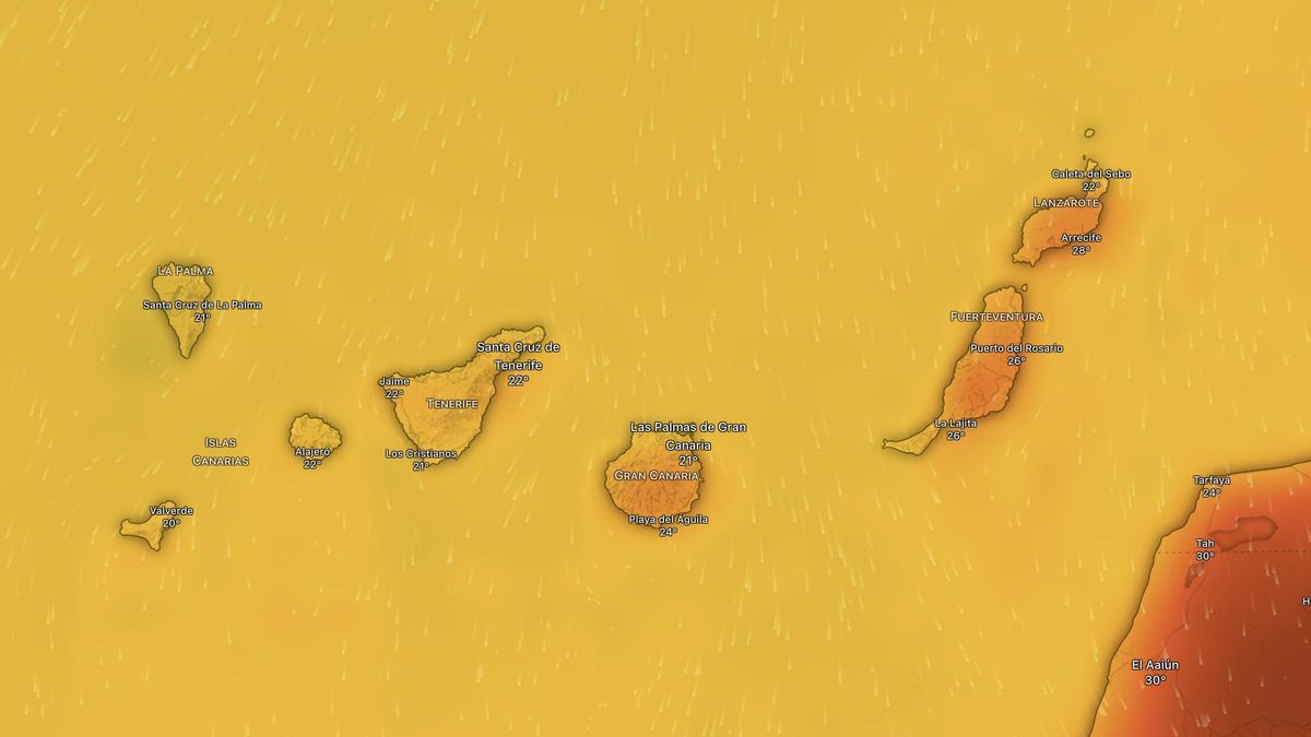
The Canary Islands are set for largely stable weather for most of this week, with cloudy intervals in the north of the islands and some light rain possible on Monday and Tuesday, while skies will be clearer elsewhere. This was highlighted on Monday by Rubén del Campo, spokesperson for the State Meteorological Agency (AEMET), who also predicted the arrival of heat across the rest of Spain, including tropical nights in some provinces. According to Del Campo, there will be some calima in Lanzarote and Fuerteventura, although it may also reach the western islands to a lesser extent, and temperatures will also rise across the archipelago, particularly the highs. He noted that on Friday and over the weekend, temperatures could exceed 32°C in the south of Tenerife and Gran Canaria, and in Fuerteventura.
Meanwhile, meteorologists from Meteored point out that the evolution of the weather towards the end of the week remains uncertain. They highlight that the main weather models are considering the possible formation of a DANA (isolated depression at high levels) near the Iberian Peninsula. Depending on its final position, this could bring intense thunderstorms—more likely in the north as things stand—or alternatively, further reinforce the inflow of warm air.
Monday
In the easternmost islands, cloudy intervals are expected with clear spells during the middle of the day, although some light, isolated rain cannot be ruled out. In the north of the mountainous islands, cloudy skies with a low chance of light, occasional rain, mainly at mid-altitudes. Elsewhere, mostly clear or sunny skies. Temperatures will see little change. Moderate northeasterly winds, with strong intervals at the southeastern and northwestern ends of the mountainous islands.
Tuesday
In Lanzarote and Fuerteventura, cloudy intervals giving way to mostly clear or sunny skies after the morning. In the north of the mountainous islands, generally cloudy skies early and late in the day, with clear skies during the day. Mostly clear or sunny elsewhere. Light, isolated rain cannot be ruled out in the north of the western islands during the early hours. Temperatures will remain almost unchanged, apart from slight to moderate increases at higher altitudes. Moderate northeasterly winds, occasionally strong at the southeastern and northwestern ends. At higher altitudes, winds will shift to an easterly component during the day and ease.
Wednesday
Cloudy skies will prevail in the west of the easternmost islands, as well as in the north of the mountainous islands below 800–1,200 metres, where occasional drizzle cannot be ruled out, with clear spells during the middle of the day. Elsewhere, mostly clear or sunny skies, apart from cloudy intervals at night on the south coasts of the central islands and La Gomera. Slight calima at high levels in Lanzarote and Fuerteventura, gradually spreading to mid-altitudes facing south and east on the other islands. Temperatures will rise slightly, especially inland, with locally moderate increases. Northeasterly winds on the westernmost islands and northerly winds elsewhere, with sea breezes in the southwest of the mountainous islands, occasionally strong on exposed slopes and inland areas of the easternmost islands.
Thursday
In the easternmost islands, light calima is expected, more significant at higher elevations, with cloudy skies in the west during the night and clear skies during the day and in other areas. On the islands with more pronounced relief, the calima will be more subtle, concentrated at mid-altitudes facing southeast. Below 900–1,100 metres in the north, cloudy skies at night, though occasional drizzle cannot be ruled out, with wide clear spells opening up during the day. Elsewhere, mostly clear or sunny skies will dominate. Temperatures will rise slightly, especially the minimums at higher altitudes; it is not out of the question that 30°C could be reached or exceeded inland areas of southern Gran Canaria and in the east of Lanzarote and Fuerteventura. Northerly winds in low-lying areas, occasionally strong on the northwestern and southeastern slopes of the mountainous islands, and light to moderate southeasterly winds at higher altitudes.
Friday
In the easternmost islands, light calima is expected, more significant at higher elevations, with cloudy skies in the west during the early hours and clear skies during the day and in other areas. On the islands with more pronounced relief, the calima will be more subtle, concentrated at mid-altitudes facing southeast. Below 600–800 metres in the north, cloudy skies at night, with wide clear spells opening up during the day. Elsewhere, mostly clear or sunny skies will dominate. Temperatures will rise slightly, with highs of 30–33°C on the southern slopes of Gran Canaria, inland areas and the southeast of the eastern islands, and locally on the southern slopes of Tenerife. Northerly winds in low-lying areas, occasionally strong on the northwestern and southeastern slopes of the mountainous islands, with possible occasional very strong gusts in coastal areas, and light to moderate southeasterly winds at higher altitudes.
What’s happening in the Canaries – straight to your phone
News, weather alerts and practical updates – direct from the islands, in English. We live here and know what’s going on – before the international media catch up. Everything lands on our WhatsApp channel – no middlemen, no algorithm. Curated for families, expats and travelers.

Rain alert declared for El Hierro as La Palma stays on pre-alert

Wednesday: showers and unstable air across the Islands

Tuesday: heavy showers and storms in El Hierro

El Hierro issued yellow warning for heavy rain

Monday: autumn showers and a cooler feel

Sunday: scattered clouds and showers on the islands

Saturday: cooler air and clearing Saharan dust

Canary Islands weather: rain and storms on the way

Friday: summer heat before an autumnal weekend
