Compiled with the help of artificial intelligence, based on Spanish-language information. Source below the article.
The sea has a new guardian watching over it. Drones are beginning to carve out a role in surveillance and rescue operations along the coast of Tenerife, both from the air and on the water, spotting swimmers in distress, locating possible victims and supporting emergency teams. This is technology that has been deployed ten times this year and is gradually gaining ground on an island that records numerous deaths by drowning. It has, in fact, already saved lives: that of a scuba diver found 20 metres off the coast of Santa Cruz thanks to these devices, and those of two people in difficulties caused by heavy swell in Santiago del Teide.
Tenerife leads the Canaries for drownings in 2026
So far in 2026, Tenerife has recorded the highest number of deaths in water accidents in the archipelago, with 19 fatalities. That represents almost 39% of the Canary Islands total and places the island as the third territory in Spain with the most fatal drownings, behind only Andalusia and Galicia. The most recent victim was recorded last Saturday, 12 September, when a diver died off the coast of Radazul, in the municipality of El Rosario. The toll since the start of the year stands at 49 deaths across the whole of the Canary Islands, including seven minors, with natural rock pools, beaches with strong currents and rocky or steep areas the settings where most rescues and incidents occur.
Thirty water rescue drones across the island
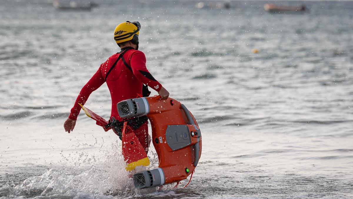
Against this backdrop, the Cabildo of Tenerife pushed ahead in July this year with the progressive rollout of 30 water rescue drones, at an investment of 240,000 euros. Of these, 28 are distributed among the municipalities with a coastline, while the remaining two are attached to the Tenerife Fire Consortium, specifically at the Guía de Isora and La Laguna stations. Known as the Island Water Rescue System (SIRA), these devices, which are orange and similar in design to a lifebuoy, can travel across the water at high speed to deliver a floatation device to a person in trouble. They can be operated remotely from land, using a radio control, or by a rescuer from the water, and they incorporate reflective strips to make them easier to locate in poor visibility.
Since their introduction, they have been used twice, with results described by the Tenerife Fire Consortium as “very satisfactory”. The first operation involved rescuing a diver whose trail had been lost while spearfishing between Puerto de Honduras and Punta Maragallo, in Santa Cruz de Tenerife. Once on the scene, and with the help of the water drone, crews located the individual more than 20 metres off the coast. The second operation involved two people who found themselves in difficulties because of the strong sea current around Playa de la Arena, in Santiago del Teide. Both interventions were successful.
Eyes in the sky as well as on the water
But the eyes on the sea are not only on the water. Tenerife also has at least 18 aerial drones distributed among various public services: 14 belong to the Cabildo’s Natural Environment department and another four to the Fire Consortium, to which can be added units from local police forces and municipal rescue services. Their functions range from monitoring protected coastline and detecting prohibited access or activities to searching cliffs, sea caves and other hard-to-reach areas during an emergency. These devices, by contrast, are equipped with high-resolution cameras, optical zoom and, in some cases, thermal sensors that make it possible to locate people among rocks or on the water even in poor visibility. From the ground, operators can hold them over a specific point, track a person at risk or send real-time images to emergency teams, making it easier to assess the situation before intervening.
As if that were not enough, some models also incorporate loudspeaker systems to issue warnings from the air to swimmers who find themselves in dangerous or restricted-access areas. So far in 2026 alone, the Tenerife Fire Consortium’s aerial drone has taken part in eight operations, according to the body’s operational records, although there may be some deployments not logged in the database given that it is a recently introduced resource. The figure represents an increase on 2023, when only one operation was recorded. The resource was also used three times in 2024 and six times during 2025, reflecting the progressive increase in its use in emergencies.
107 critical points identified along the coastline
The introduction of these resources forms part of an analysis carried out by the emergency services which has identified 107 critical points along the Tenerife coastline, where half of all rescues are concentrated. This strategy is complemented by the first regional beach safety plan being prepared by the Government of the Canary Islands, with the aim of filling the existing legal gap and making it easier for municipalities with fewer than 20,000 inhabitants to have lifeguard and rescue services with legal backing and funding.
What’s happening in the Canaries – straight to your phone
News, weather alerts and practical updates – direct from the islands, in English. We live here and know what’s going on – before the international media catch up. Everything lands on our WhatsApp channel – no middlemen, no algorithm. Curated for families, expats and travelers.
Canary Islands look to volcanic heat for energy

Canary Islands’ ancient potatoes face climate threat
Gran Canaria wildfire breaks out in Telde
Court backs Chira-Soria power plant in Gran Canaria
Twelve earthquakes recorded across the Canary Islands

The Tenerife ghost town built for lepers who never came

La Palma’s quantum telescope project to boost island economy

Canary Islands forests store 25% more carbon than thought
New map reveals 60+ closed beaches in Canary Islands