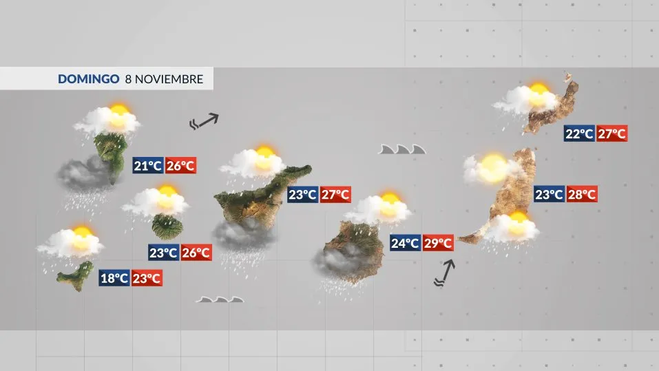
Compiled with the help of artificial intelligence, based on weather data. Source below the article.
Storm Bruna sweeps across the Canary Islands this Sunday, bringing the most unsettled conditions of the week. Expect heavy showers, thunderstorms and hail, with fierce gusts on the high ground and an increasingly rough Atlantic.
What to expect across the Islands
Cloud will spread from west to east through the day, with moderate to heavy rain that may turn persistent and arrive with thunderstorms and hail. The greatest risk of storms sits over western La Palma and the west- and south-facing slopes of the other islands.
Daytime temperatures will dip, most noticeably inland, while the nights turn slightly milder – a shift felt most clearly on the eastern islands.
Winds blow from the southwest, moderate along the coasts with stronger spells, and strong to very strong on the mid-slopes and summits. Gusts could exceed 100km/h on the peaks of La Palma and Tenerife. Out on the Atlantic, combined swell from the west-southwest will push waves of 2 metres or more on north- and west-facing coasts, with conditions worsening after dark.
Island-by-island forecast
Tenerife
Cloudy or overcast with likely heavy showers and thunderstorms carrying hail, especially across the south, east and west. Snow cannot be ruled out on the Pico del Teide. Rain will ease later. Moderate southwest winds, with gusts above 100km/h possible on the mid-slopes and summits. Temperatures of 23–26°C in Santa Cruz.
Gran Canaria
Scattered high and medium cloud will thicken, bringing likely intense showers with thunderstorms and hail, particularly on the summits and the south and west, where rain may turn persistent. Moderate southwest winds with gusts above 90km/h possible on the high ground. A high of 29°C in Las Palmas.
Lanzarote
Scattered high and medium cloud turning cloudier, with locally heavy showers, thunderstorms and hail likely, above all late in the day. Moderate southwest winds, stronger in the north. Temperatures of 22–27°C in Arrecife.
Fuerteventura
Scattered high and medium cloud turning cloudier, with the chance of a locally heavy shower and thunderstorm with hail towards the evening. Moderate southwest winds, stronger in the north. Temperatures of 23–28°C in Puerto del Rosario.
La Palma
Overcast with likely thunderstorms and hail. Rain will ease through the afternoon. Moderate southwest winds on the coast and strong on the mid-slopes and summits, with local gusts above 100km/h possible. Temperatures of 21–26°C in Santa Cruz de La Palma.
La Gomera
Cloudy with intense showers inland and across the southern half, where thunderstorms and hail may develop. Rain will ease later. Moderate southwest winds, with very strong gusts on the summits. Temperatures of 23–26°C in San Sebastián.
El Hierro
Cloudy with thunderstorms that may turn heavy and persistent, with hail. Conditions will improve through the afternoon. Moderate southwest winds on the coast and strong on the mid-slopes and summits, with gusts above 90km/h. Temperatures steady.
La Graciosa
Scattered high and medium cloud, with the chance of an isolated thunderstorm. Moderate southwest winds. Temperatures of 22–28°C in Caleta de Sebo.
Warnings in force
AEMET has issued warnings for strong winds and rough seas. Take care on exposed coasts and high ground, where gusts may top 100km/h, and avoid summit routes on La Palma and Tenerife while the wind is at its worst. Sea conditions will deteriorate further overnight, so check local advice before heading to the water.