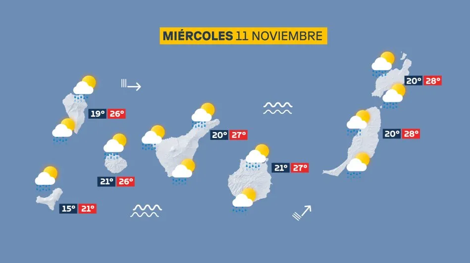
Compiled with the help of artificial intelligence, based on weather data. Source below the article.
Storm Charles sweeps across the Islands
The Canary Islands are in for a turbulent Wednesday as Storm Charles drives heavy showers, gale-force winds and rough seas across the archipelago. Gusts could reach 120 km/h on the highest peaks of Tenerife and La Palma, while ocean swell may top three metres along north and west coasts.
General conditions
Cloudy skies will dominate, with moderate rain spreading from west to east and the chance of strong downpours. Showers may become persistent on south and west-facing slopes. Temperatures will climb slightly, though strong south-westerly winds will make it feel cooler in exposed spots. The Atlantic stays rough, with waves over three metres on northern and western shores, particularly around La Palma.
Tenerife
Overcast with moderate rain and possible strong, persistent showers, especially in the west and on the peaks. Strong south-westerly winds will be most intense across mid-altitude areas, summits and the north-west and south-east coasts, where gusts could exceed 120 km/h. Winds ease towards the end of the day. Temperatures in Santa Cruz: 20–27°C.
Gran Canaria
Cloudy with moderate rain and the odd heavy shower, most likely in the south-west where they may linger. Strong south-westerly winds, strongest over mid-altitudes, summits and the north-west and south-east coasts, with gusts up to 100 km/h. Winds ease late in the day. Temperatures in Las Palmas: 21–27°C.
Lanzarote
Scattered clouds will thicken into overcast skies with moderate rain, and a thundery shower cannot be ruled out in the afternoon. Strong south-westerly winds with gusts over 90 km/h, mainly in the north and west, easing by the evening. Temperatures in Arrecife: 20–28°C.
Fuerteventura
Scattered clouds will build from midday, with strong showers likely in the afternoon. Strong south-westerly winds with gusts above 90 km/h in the north and west, easing overnight. Temperatures in Puerto del Rosario: 20–28°C.
La Palma
Cloudy with moderate rain and possible heavy showers, likely persistent on the west side through the morning. Strong south-westerly winds with possible hurricane-force gusts above 120 km/h across mid-altitudes and the north-west and south-east coasts. Winds ease in the afternoon. Temperatures in Santa Cruz de La Palma: 19–26°C.
La Gomera
Overcast with rain and the chance of a heavy midday shower. Strong south-westerly winds with gusts up to 100 km/h over mid-altitudes, summits and the north-west and south-east coasts. Winds will ease later. Temperatures in San Sebastián: 21–26°C.
El Hierro
Cloudy or overcast with moderate rain and possible heavy showers. Strong south-westerly winds with gusts reaching 100 km/h on summits and in the north-west, easing in the afternoon. Temperatures unchanged.
La Graciosa
Scattered clouds with thundery showers likely in the afternoon. Strong south-westerly winds with gusts above 80 km/h. Temperatures in Caleta de Sebo: 22–27°C.
Warnings for residents and visitors
Anyone heading out should take care near exposed coasts and high ground, where gusts could be dangerous. Rough seas make the Atlantic best avoided along north and west shores for now — conditions will improve as winds ease through the day.