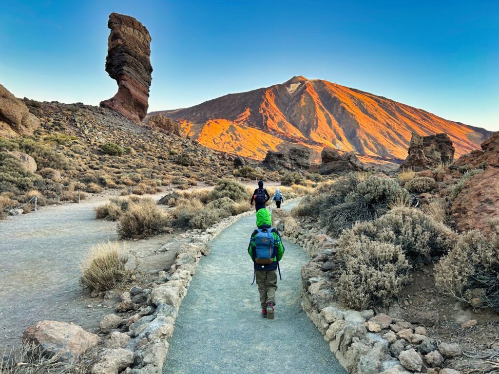
At 3,715 meters, Mount Teide is the highest point in Spain and one of those mountains that genuinely earns its reputation. We’ve hiked it several times now – different seasons, different routes, once with both kids in tow – and it still manages to surprise us. A Mount Teide hike isn’t just a walk to a high point; you’re moving through a UNESCO-protected volcanic landscape that looks like it belongs on another planet, with views on clear days that stretch all the way to the African coast. The good news: you don’t need to be an elite mountaineer to climb Mount Teide. The bad news: you do need to plan ahead – seriously ahead – because the Teide permit system is strict, the slots fill fast, and since January 2026 there are new fees that catch a lot of visitors off guard. Whether you’re aiming for the Teide summit under your own steam or combining hiking with the cable car, this guide covers the routes, the permits, the costs, and the practical details that actually matter on the mountain.
- Understanding Mount Teide: Spain's Volcanic Giant
- Mount Teide Permit System: Essential Planning Information
- Mount Teide Hike Routes: Choose Your Adventure
- Preparing for Your Mount Teide Hike
- Weather and Seasonal Considerations
- Safety Considerations and Emergency Procedures
- Logistics and Practical Information
- Alternatives When Permits Aren't Available
- Weather Patterns and Best Timing
- Common Mistakes and How to Avoid Them
- Frequently Asked Questions
- Your Mount Teide Adventure Awaits
- Rent our home
Understanding Mount Teide: Spain’s Volcanic Giant
Geological Marvel and UNESCO World Heritage
Measured from its oceanic base, Mount Teide ranks among the three tallest volcanic structures on the planet – a fact that puts its scale in perspective long before you set foot on the trail. This stratovolcano began forming approximately 170,000 years ago and remains active today, with its last eruption occurring in 1909 from nearby Chinyero volcano.
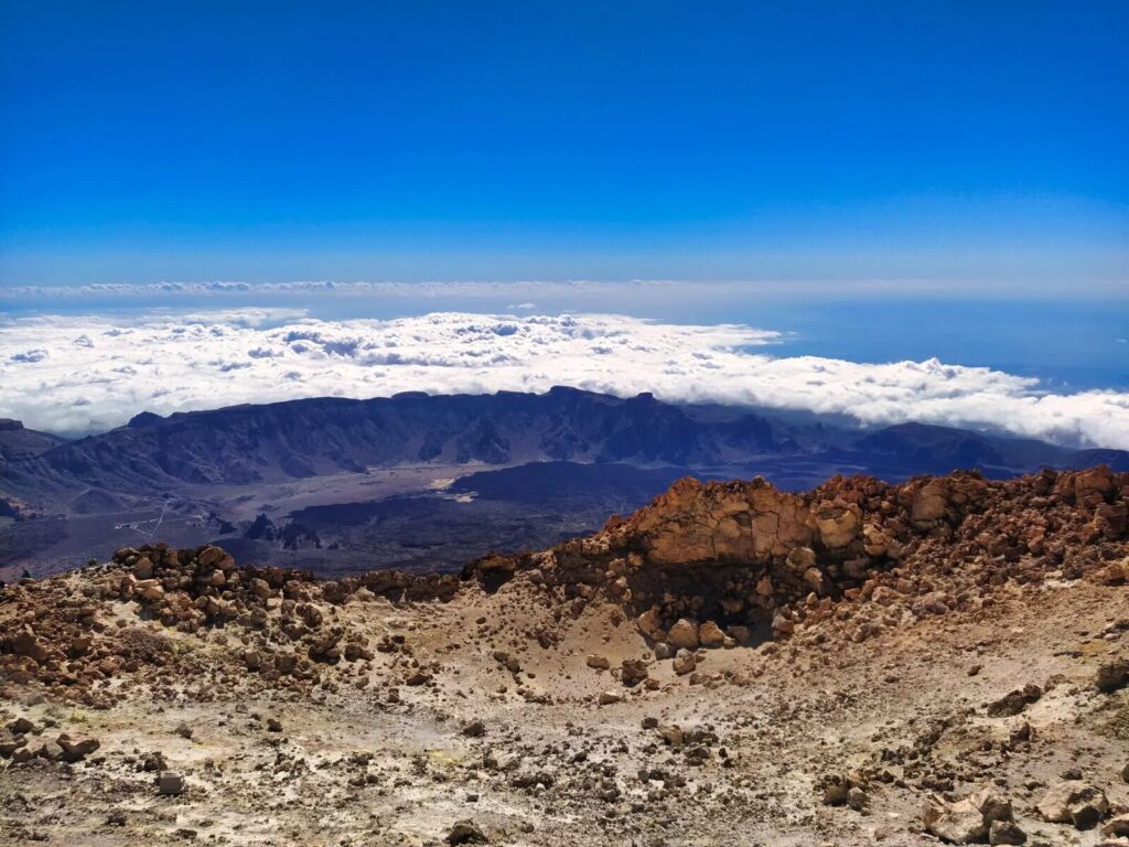
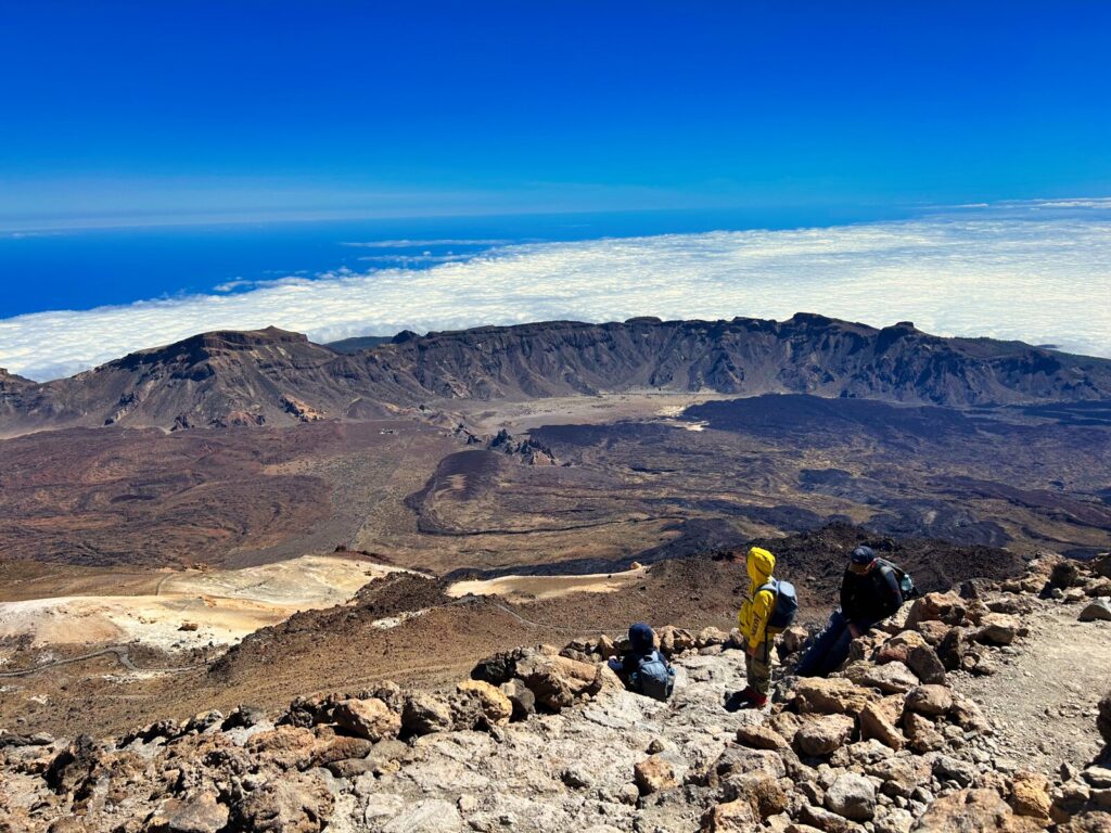
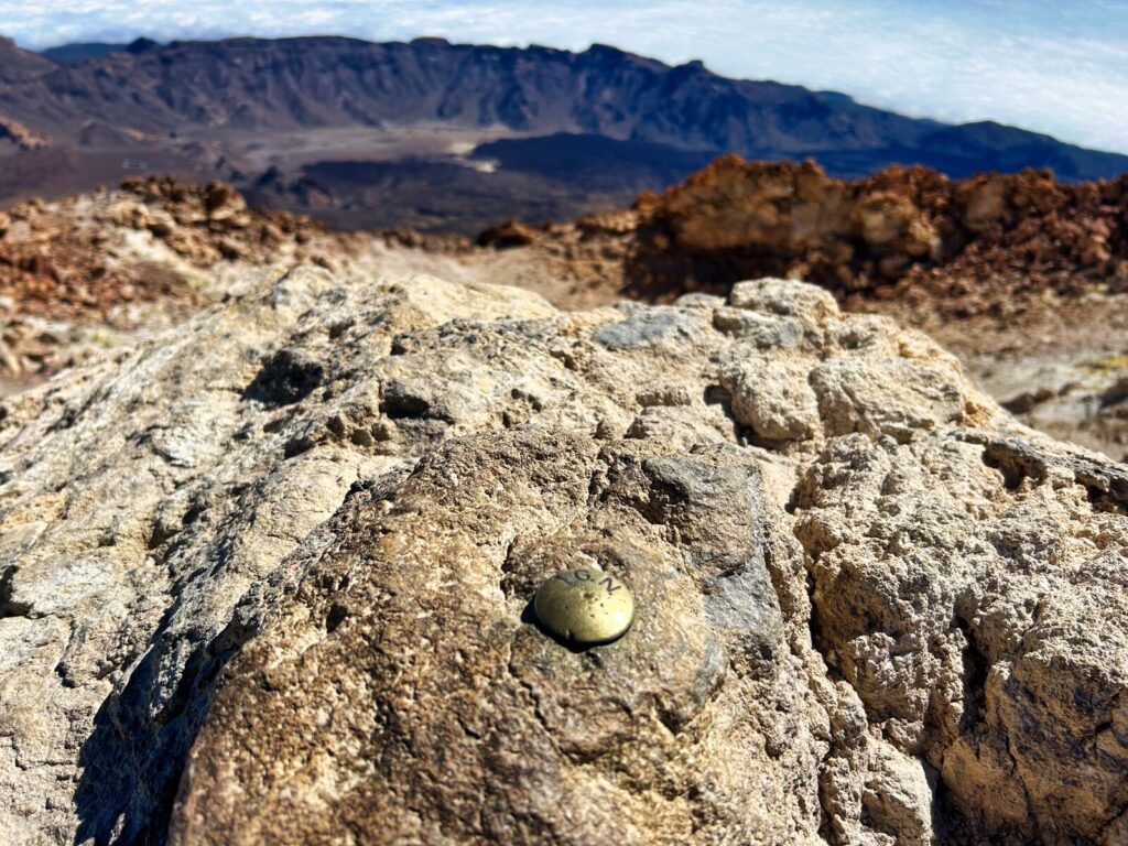
The Teide National Park, designated as a UNESCO World Heritage site in 2007, encompasses 18,990 hectares of otherworldly volcanic landscapes. The Las Cañadas caldera, measuring 16 kilometers in diameter, creates a natural amphitheater that houses this magnificent peak and provides the dramatic setting for your Mount Teide hike.
Cultural Significance and Ancient Legends
For the indigenous Guanche people, Mount Teide held profound spiritual significance. They believed the volcano was home to Guayota, a malevolent demon who had captured Magec, the god of light. According to legend, the supreme god Achamán defeated Guayota and sealed him within the volcano, with the white summit representing the cork that prevents the demon’s escape.
Today, this cultural heritage adds mystique to every Mount Teide climb, reminding hikers that they’re not just conquering a peak, but walking through landscapes steeped in ancient mythology and geological history.
Mount Teide Permit System: Essential Planning Information
Understanding Permit Requirements
The most crucial aspect of planning to climb Mount Teide involves securing the necessary permits. The Teide permit system, introduced to protect this fragile volcanic environment, requires advance booking for accessing the summit trail and several approach routes.
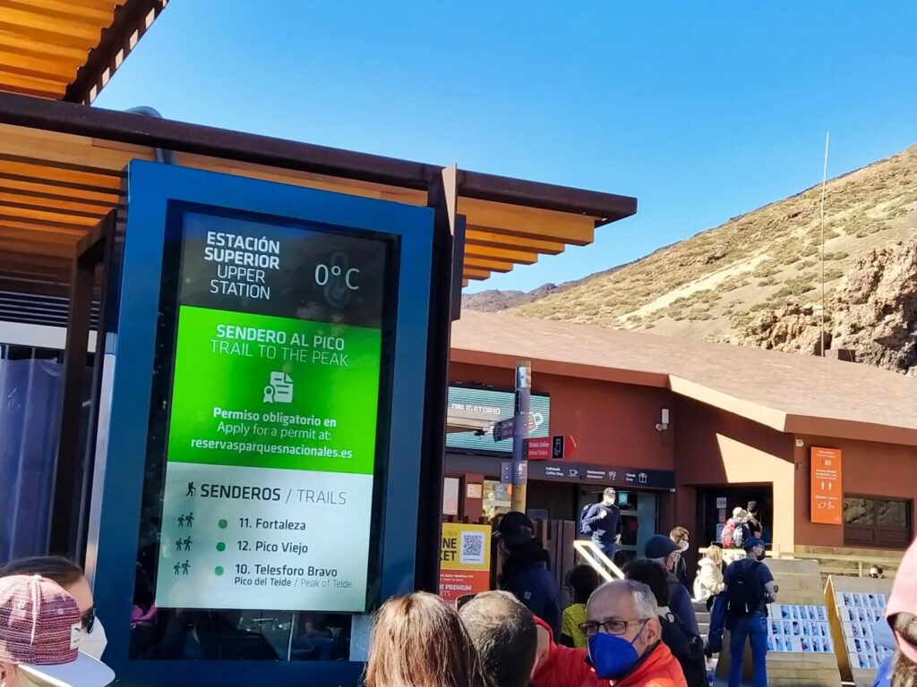
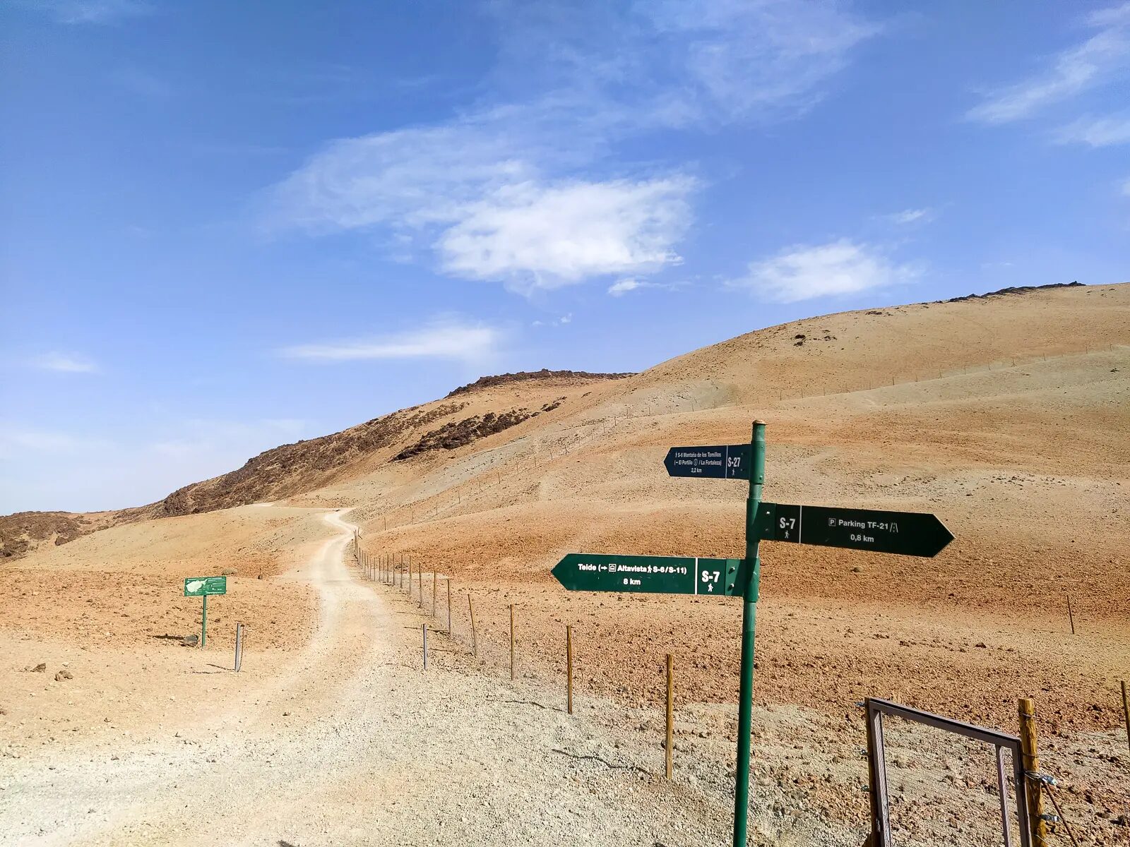
Summit Access (Trail 10 – Telesforo Bravo):
- Required for final 163-meter ascent from La Rambleta (3,555m) to summit (3,715m)
- Maximum 300 permits issued daily
- Four time slots: 9:00-11:00, 11:00-13:00, 13:00-15:00, 15:00-17:00
- Special sunrise permits: 6:00-9:00 (50 people daily)
- Special sunset permits: 18:00-22:00 (50 people daily)
- Since January 2026, an “Ecotasa” applies. For non-residents, the summit trail (PNT 10) costs €15 without a guide and €10 with a guide. The Montaña Blanca trail (PNT 07) costs €6 on weekdays and €10 on weekends and holidays
Approach Trail Permits (Required since January 2025):
- Trail 7 (Montaña Blanca): Most popular hiking route to cable car station
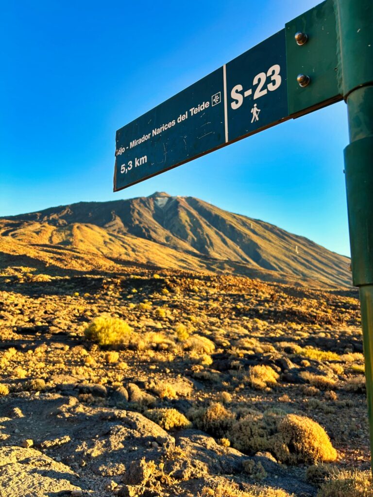
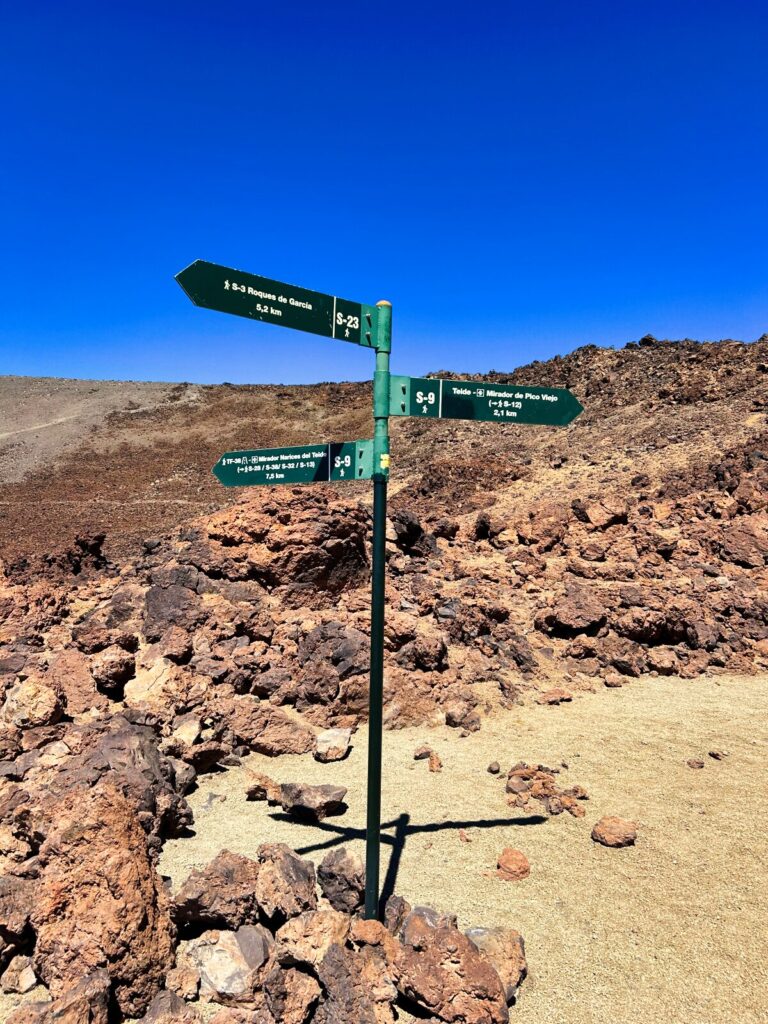
- Trail 9 (Teide-Pico Viejo): Challenging route through volcanic landscapes
- Trail 23 (Los Regatones Negros): Alternative approach with unique geology
- Each trail limited to 50-100 daily hikers
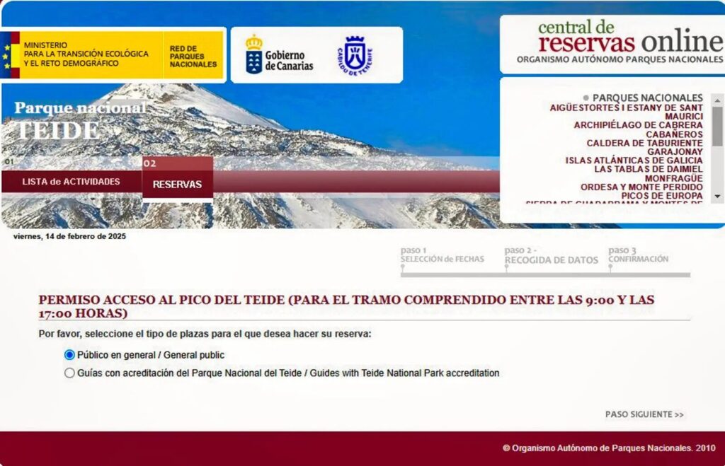
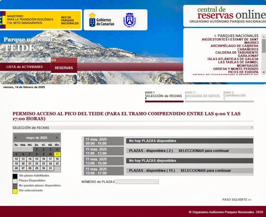
How to Secure Your Teide Permit
Summit Permits:
- Visit the official Tenerife ON platform (website or app). Bookings for the summit trail (PNT 10) open every Monday at 7:00 AM (Canary Islands time) with a 28-day advance booking window. Approach trails can be booked 21 days in advance
- Select “PERMISO ACCESO AL PICO DEL TEIDE”
- Choose your preferred date and time slot
- Provide exact personal details for all participants
- Bring original ID documents (Passport/ID) that match your reservation details. If you claim resident discounts, you must also present your Certificate of Empadronamiento or DNI/NIE with a Canary Islands address.
- Be aware of the strict rules from January 2026: Paid reservations cannot be modified, canceled, or refunded unless the trail is closed due to weather or cable car suspension. Additionally, if you do not show up for a free permit without canceling, you face a “No-Show” penalty and will be banned from making new reservations for 3 months.
Approach Trail Permits:
- Access TenerifeON platform for trail-specific bookings
- New slots released Mondays at 7:00 AM Canary time
- Reservations available 21 days in advance
- Popular routes fill within minutes of release
Pro Tip: Book permits 3-6 months in advance, especially for peak season (July-September) and sunrise/sunset slots. If permits aren’t available, organized tour companies maintain separate allocations that might offer alternatives.
One thing nobody tells you: Monday mornings at 7:00 AM Canary time is not a casual refresh situation. We’ve had the page crash, the slot disappear mid-booking, and once watched a sunrise permit vanish in under 90 seconds. Have your ID numbers ready, your party details copy-pasted, and don’t assume a second attempt is coming
Mount Teide Hike Routes: Choose Your Adventure
Option 1: Cable Car + Summit Trail (Easiest)
Route Overview:
- Take Teleférico cable car from base station (2,356m) to La Rambleta (3,555m)
- Hike final 650m summit trail with 160m elevation gain
- Total hiking: 30-45 minutes each way
- Total experience: 2-3 hours including cable car time
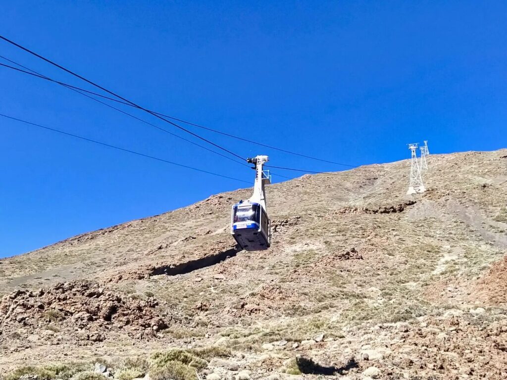
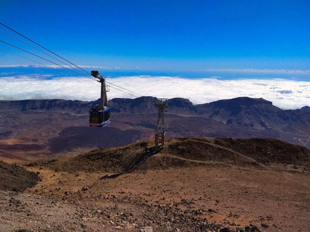
What to Expect: The cable car journey provides spectacular aerial views of the volcanic landscape while whisking you 1,200 meters upward in just 8 minutes. From La Rambleta station, the summit trail represents a challenging but achievable climb for most fitness levels.
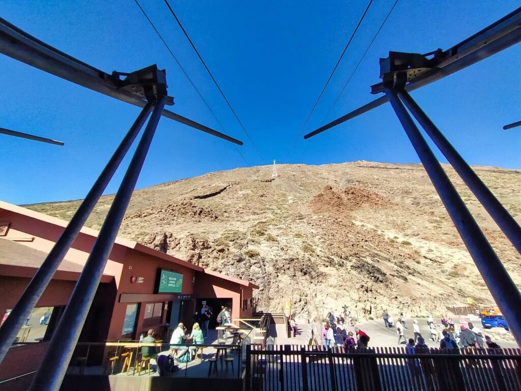
The path zigzags steeply upward through volcanic scree and solidified lava formations. Despite its short distance, the thin air at this altitude makes every step demanding. The final approach offers increasingly dramatic views across the Canary Islands archipelago.
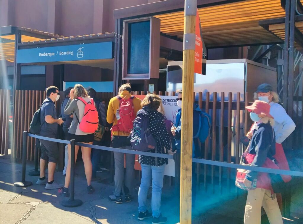
Cable Car Details:
- Operating hours are 9:00 to 17:00. The last ascent is at 16:00, and the last descent is strictly at 16:40
- Adult tickets: €42.00 round trip, €23.50 one way. Children (3-13): €21.00 round trip
- Book online at volcanoteide.com to avoid queues
- Weather dependent – can close due to high winds
Option 2: Montaña Blanca Trail + Summit (Most Popular)
Route Overview:
- Start: Montaña Blanca parking area (2,348m)
- Distance: 8.3km to La Rambleta + 0.65km to summit
- Elevation gain: 1,367m total
- Hiking time: 5-6 hours ascent + 45 minutes summit
- Difficulty: Challenging due to altitude and distance
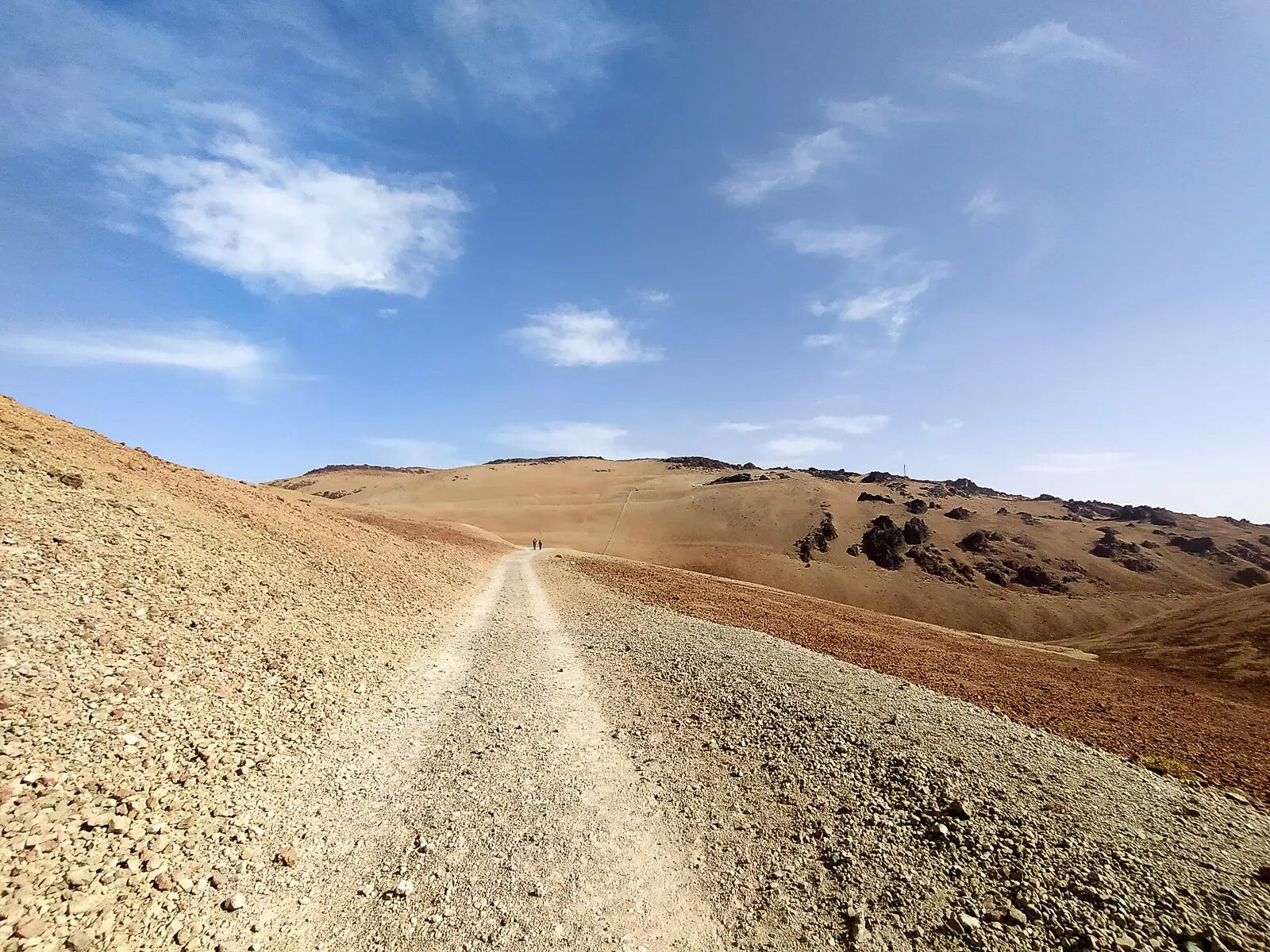
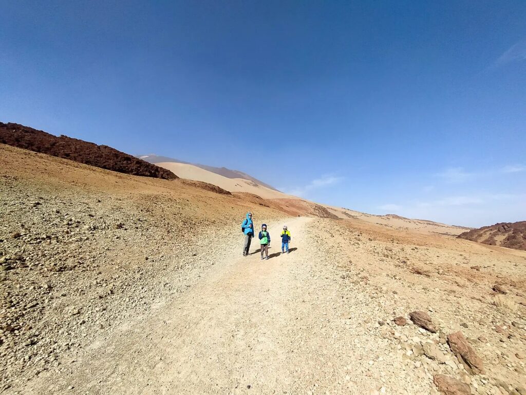
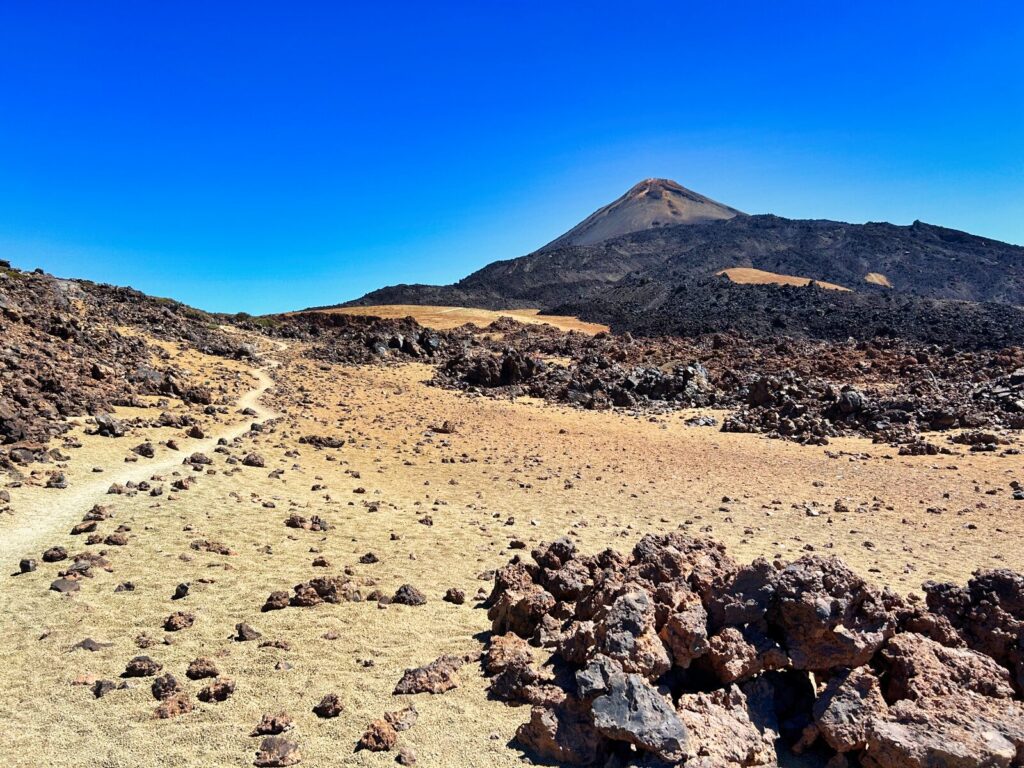
Trail Description: This classic Mount Teide hike begins across pumice fields that give Montaña Blanca (White Mountain) its name. The initial 3 kilometers cross relatively flat volcanic terrain, allowing gradual acclimatization to the altitude.
The middle section climbs steadily through sparse vegetation and increasingly dramatic volcanic formations. As you gain elevation, the views expand to encompass the entire Las Cañadas caldera and neighboring peaks.
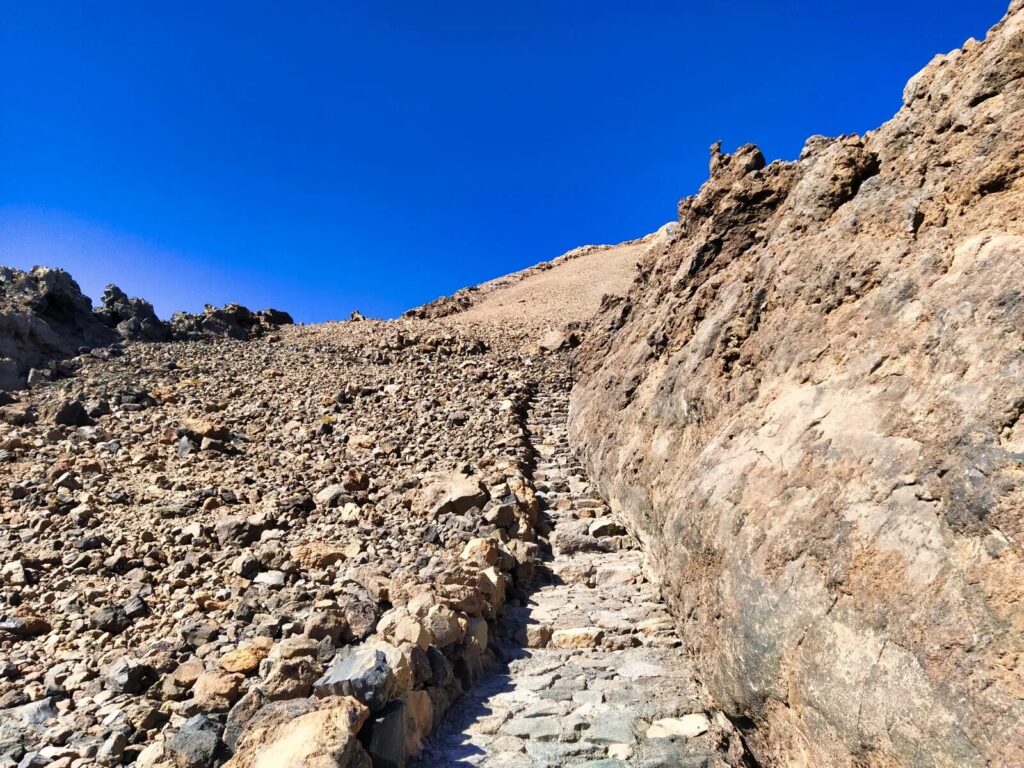
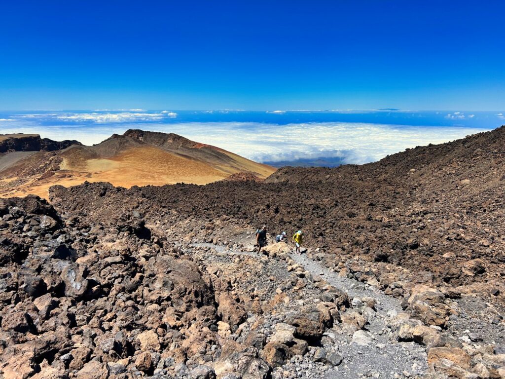
The final approach to La Rambleta becomes significantly steeper, with switchbacks carved into volcanic slopes. Here, the thin air at over 3,500 meters makes every step challenging, requiring frequent rest stops and steady pacing.
We did this route with our boys when they were 8 and 10, and the pumice fields at the start were genuinely a highlight – both of them were convinced they were walking on the moon. The middle section is where altitude starts to bite, though. Our older one had a persistent headache from around 3,200 meters that didn’t shift until we descended. Worth knowing if you’re bringing kids.
Trail Highlights:
- Diverse volcanic geology from pumice fields to lava flows
- Spectacular views developing throughout the ascent
- The Altavista Refuge area (3,260m) – the refuge is currently closed, and setting up a bivouac requires a special permit processed in Spanish.
- Junction with cable car passengers at La Rambleta
- Alpine desert ecosystem with endemic plant species
IMPORTANT – NEW FEES FROM JANUARY 2026: If you are not a Tenerife resident, the Montaña Blanca approach trail (between 9:00 AM and 3:00 PM) requires an eco-tax of €6 on weekdays and €10 on weekends/holidays.
Option 3: Teide-Pico Viejo Trail + Summit (Most Scenic)
Route Overview:
- Start: Near Las Narices del Teide parking (TF-38 road)
- Distance: 9.6km to La Rambleta + 0.65km to summit
- Elevation gain: 1,450m total
- Hiking time: 6-7 hours ascent + 45 minutes summit
- Difficulty: Very challenging – for experienced hikers only
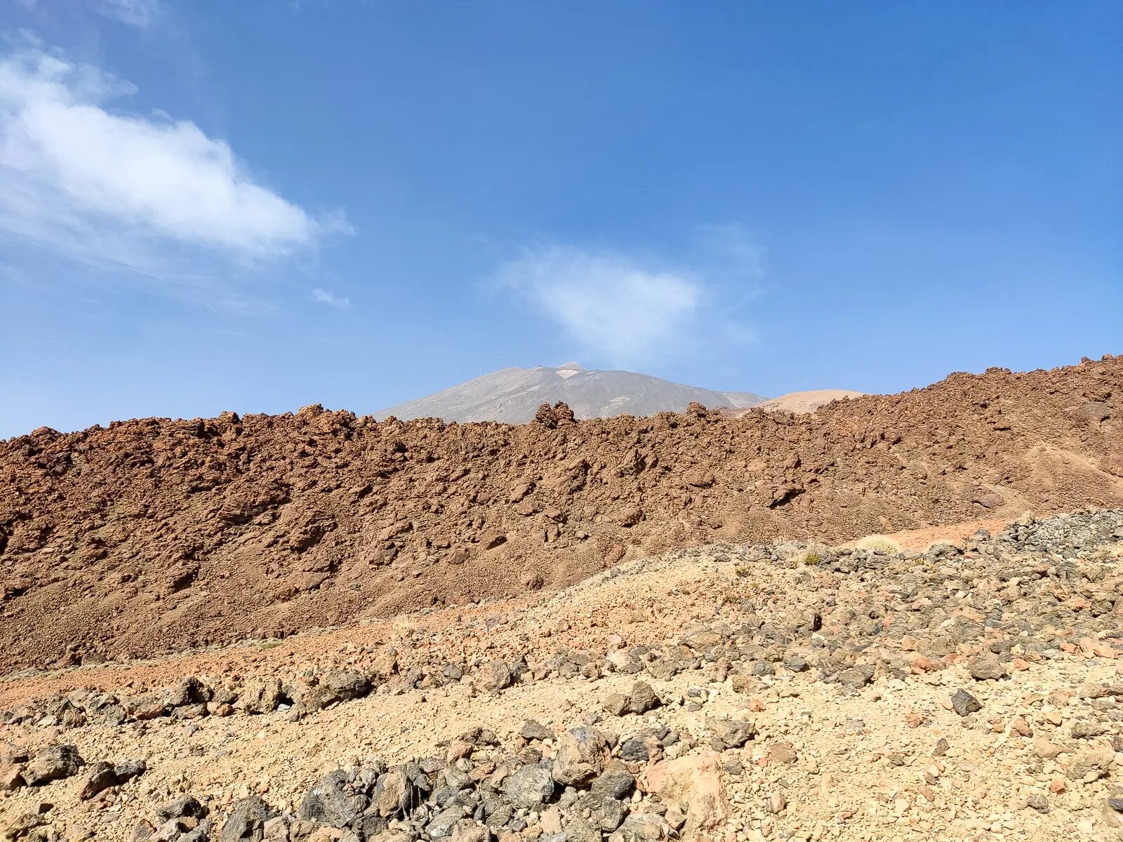
What Makes This Route Special: This demanding Mount Teide climb offers the most diverse and spectacular scenery of any route. You’ll traverse landscapes from the 1798 eruption, circle the massive Pico Viejo crater (800m diameter), and witness the incredible geological forces that shaped this volcanic wonderland.
The route passes Las Narices del Teide (“Teide’s Nostrils”), the volcanic vents from which the last eruption emerged. The multicolored crater walls of Pico Viejo display layers of different volcanic periods – black, red, yellow, and white strata telling the story of countless eruptions.
Advanced Planning Required:
- Requires both Trail 9 permit and summit permit
- Early start essential (6:00-7:00 AM) due to length
- Weather monitoring crucial – exposure to sudden changes
- Navigation skills helpful in poor visibility
- Minimum 4 liters water per person
Option 4: Complete Hiking Experience (Most Challenging)
For Ultimate Adventure: Experienced mountaineers can combine ascent and descent entirely on foot, creating epic 12-16 hour adventures. Popular combinations include ascending via Montaña Blanca and descending via different routes, though this requires careful logistics planning and exceptional fitness.
Sunrise/Sunset Expeditions: Special permits allow summit access during magical golden hours (6:00-9:00 AM and 6:00-10:00 PM) and remain completely FREE for everyone. Sunrise climbs typically require 2:00-3:00 AM starts for Montaña Blanca route, while sunset permits offer spectacular evening views but require headlamp descents.
Preparing for Your Mount Teide Hike
Essential Equipment and Clothing
Equipment on Mount Teide isn’t just a recommendation – since recent rule changes, arriving without the right gear can get you turned back at the trailhead or hit with a fine of up to €600. Hiking without specific gear like mountain shoes with lug soles, long trousers, warm jackets, hats, gloves, a fully charged phone, and a flashlight can result in fines of up to €600 and being denied entry to the trails.
Essential Gear:
- Minimum 3 liters water per person (more for full ascent routes)
- High-energy snacks and full meals for longer routes
- Sunscreen SPF 50+ (UV intensity extreme at altitude)
- Sunglasses with UV protection
- Headlamp with extra batteries (essential for sunrise/sunset)
- First aid kit including altitude sickness medication
- Trekking poles (highly recommended for descent)
- Emergency blanket and whistle
Physical Preparation and Health Considerations
Fitness Requirements: Climbing Mount Teide demands good cardiovascular fitness and strong legs. The combination of altitude, steep terrain, and potentially harsh weather creates challenges even for experienced hikers. Begin training at least 6-8 weeks before your trip with regular cardio exercise and hill climbing.
Altitude Considerations: At 3,715 meters, Mount Teide’s summit sits well above the altitude where most people begin experiencing effects of reduced oxygen. Symptoms of altitude sickness include headaches, nausea, fatigue, and dizziness. Plan for slower ascent times and more frequent rest stops than at sea level.
Health Precautions: Consult your doctor before attempting this climb if you have cardiovascular issues, respiratory problems, or high blood pressure. Pregnant women and children under 3 years should avoid high-altitude exposure.
Weather and Seasonal Considerations
Understanding Teide’s Unique Climate
Mount Teide creates its own weather patterns, with conditions changing rapidly between base and summit. While coastal Tenerife enjoys warm, stable weather, the peak can experience snow, high winds, and freezing temperatures even in summer.
Temperature Variations:
- Base elevation (2,000m): Similar to coastal temperatures
- Cable car station (2,356m): 5-10°C cooler than coast
- Summit (3,715m): 15-20°C cooler than coast, can reach -10°C in winter
Seasonal Guide:
Summer (June-September):
- Best weather stability and longest daylight hours
- Summit temperatures: 5-15°C during day, can drop below freezing at night
- Highest demand for permits – book far in advance
- Heat at lower elevations requires very early starts
Winter (December-March):
- Summit often snow-covered with possible ice conditions
- Shorter daylight hours limit hiking windows
- Fewer crowds but weather more unpredictable
- Requires winter mountaineering equipment and experience
Spring/Autumn (April-May, October-November):
- Ideal climbing conditions with moderate temperatures
- Lower permit demand than summer
- Stable weather patterns with excellent visibility
- Perfect for photography with dramatic lighting
Weather Safety and Planning
Always check current conditions at www.aemet.es before your hike. The cable car frequently closes due to high winds, which can strand summit hikers who planned to descend mechanically. Monitor weather forecasts for several days before your climb and have backup plans ready.
Wind conditions deserve special attention – gusts above 3,000 meters can be dangerous even for experienced mountaineers. If sustained winds exceed 50 km/h, consider postponing your Mount Teide hike.
Safety Considerations and Emergency Procedures
Recognizing and Managing Altitude Sickness
Altitude sickness doesn’t discriminate – it can hit fit, experienced hikers just as easily as beginners, and on a Mount Teide hike you’re above 2,500 meters before you’ve even reached the cable car station. Early symptoms include headache, nausea, fatigue, and dizziness. More serious symptoms include confusion, difficulty walking, and shortness of breath at rest.
Prevention Strategies:
- Ascend gradually when possible
- Stay well-hydrated (but don’t overhydrate)
- Avoid alcohol and sleeping pills before climbing
- Eat light, high-carbohydrate meals
- Listen to your body and don’t ignore symptoms
When to Descend Immediately:
- Severe headache not relieved by rest and pain medication
- Vomiting or inability to keep food/water down
- Confusion or change in mental state
- Difficulty walking or coordination problems
- Shortness of breath at rest
Emergency Contacts and Procedures
Emergency Numbers:
- General Emergency: 112
- Civil Guard Mountain Rescue: 062
- Medical Emergency: 061
Emergency Preparedness: Inform someone of your climbing plans, including intended route, start time, and expected return. Carry a fully charged mobile phone, though coverage can be spotty above 3,000 meters. Consider carrying a personal locator beacon for remote routes.
Navigation and Route Finding
While main trails are well-marked, weather conditions can reduce visibility to mere meters. Download offline maps to your phone and carry a compass as backup. GPS coordinates for key waypoints:
- Montaña Blanca Trailhead: 28°16’22.8″N 16°35’45.6″W
- La Rambleta Cable Car Station: 28°15’29.4″N 16°37’44.4″W
- Teide Summit: 28°16’20.4″N 16°38’22.2″W
Logistics and Practical Information
Transportation to Trailheads
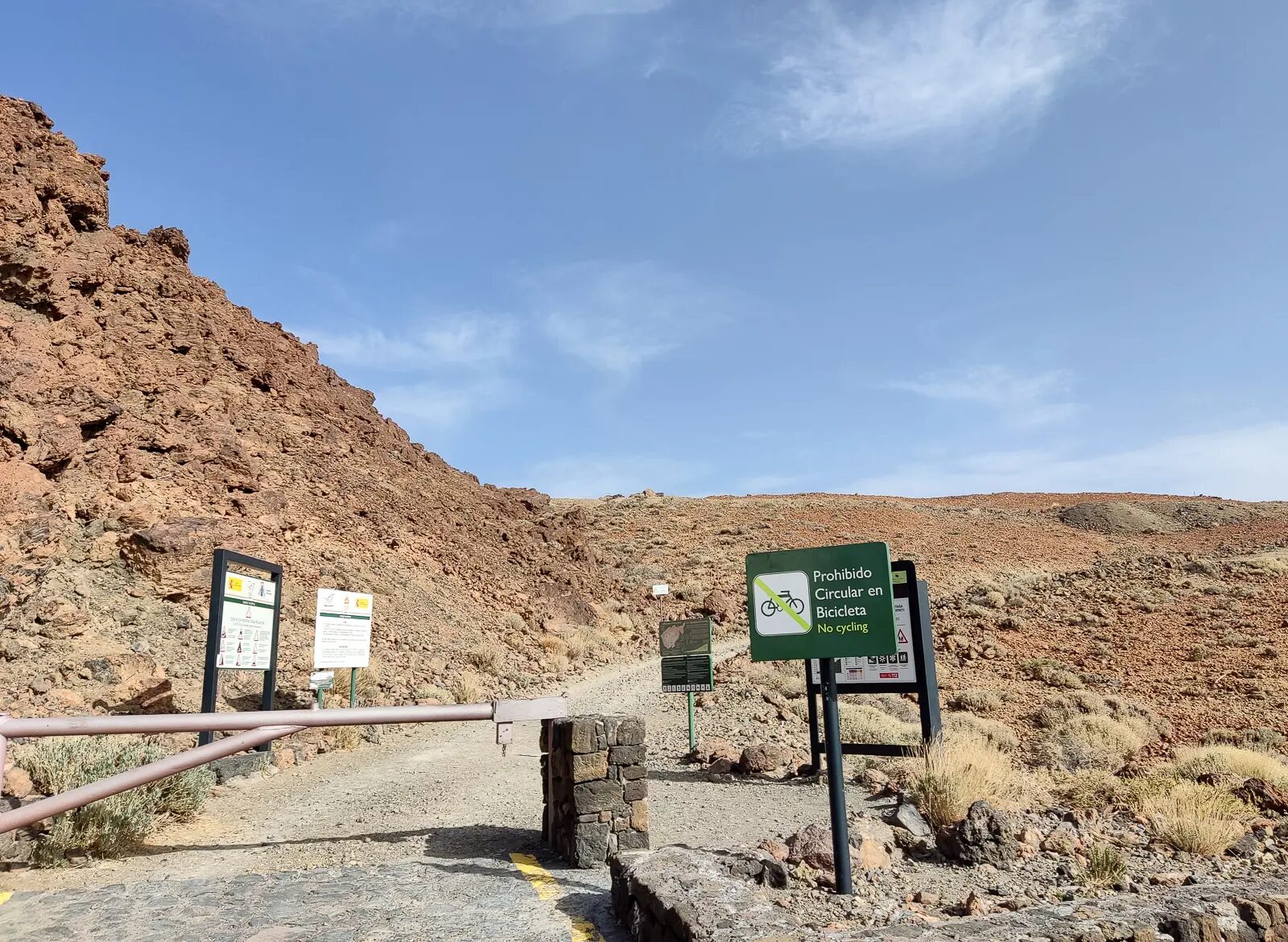
Between 09:00 and 13:00, private cars are restricted in high-traffic zones, and pre-booking a parking space via the official website is required. The speed limit inside the park is 50 km/h. Free TITSA shuttle buses (guaguas lanzadera) operate from Vilaflor, La Esperanza, and Aguamansa. Note that between 14:00 and 17:00, these buses operate exclusively to take visitors back down.
Public Transportation: Limited bus service operates to the cable car base station:
- Line 348: Departs Puerto de la Cruz at 9:30 AM, La Orotava at 9:45 AM, arriving at the Cable Car at 10:58 AM. The return bus departs the Cable Car at 16:05
- Line 342: Departs Costa Adeje at 9:25 AM, Los Cristianos at 9:40 AM, arriving at the Cable Car at 11:06 AM. The return bus departs the Cable Car at 15:40
Accommodation Strategies
For Hiking Focus: Stay in locations providing easy access to multiple trailheads. Our Tenerife itinerary guide recommends central accommodations that optimize travel times to various Mount Teide routes.
Day Before Climbing: Stay hydrated, eat well, and get adequate sleep. Avoid alcohol and limit caffeine. Pack everything the night before and set multiple alarms – most serious climbs require pre-dawn starts.
Photography and Documentation
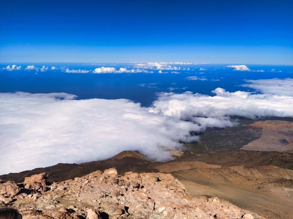
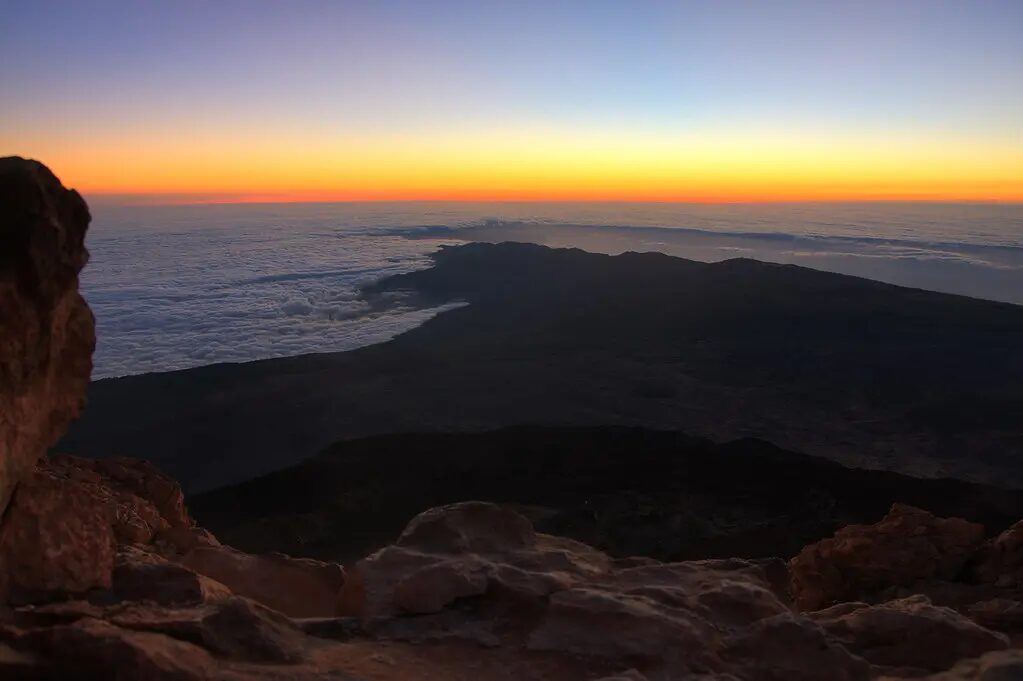
Mount Teide offers some of the world’s most spectacular mountain photography opportunities. The summit panorama encompasses all seven Canary Islands on clear days, with the African coast visible 300 kilometers away.
Best Photo Opportunities:
- Sunrise from summit (requires special permit and night ascent)
- View across Las Cañadas caldera during ascent
- Summit panorama with other Canary Islands
- Volcanic formations and endemic plant life
- “Sea of clouds” phenomenon from various elevations
Photography Equipment: Bring extra batteries (cold temperatures drain power quickly) and protect camera gear from volcanic dust. A polarizing filter helps manage intense UV reflection from light-colored volcanic surfaces.
Alternatives When Permits Aren’t Available
Spectacular Viewpoints Without Permits
If Teide summit permits aren’t available, numerous alternatives offer incredible volcanic experiences:
From La Rambleta (Cable Car Access):
- Trail 11: Mirador de La Fortaleza (25-minute hike, 24m elevation gain)
- Trail 12: Mirador de Pico Viejo (30-minute hike, 54m elevation gain)
Both trails provide stunning panoramic views without requiring summit permits and showcase different perspectives of the volcanic landscape.
Other Teide National Park Hikes:
- Roques de García circuit (3.5km, 2 hours)
- Siete Cañadas trail (8km, 3 hours)
- Arenas Negras route (4km, 2 hours)
Our comprehensive Tenerife hiking guide details 15+ epic routes throughout the island, including alternatives when Teide permits aren’t available.
Stargazing Opportunities
Teide National Park holds “Starlight Reserve” certification, recognizing it as one of the world’s best astronomical observation sites. Even without climbing permits, nighttime visits offer incredible stargazing experiences above the cloud line.
Weather Patterns and Best Timing
Understanding Tenerife’s unique climate patterns helps optimize your Mount Teide hike experience. Our detailed Tenerife weather guide explains seasonal variations, but mountain conditions deserve special consideration.
Optimal Climbing Windows:
- April-June: Excellent conditions, moderate crowds, stable weather
- September-November: Perfect temperatures, fewer tourists, clear visibility
- July-August: Most reliable weather but highest demand for permits
- December-March: Advanced conditions, possible snow/ice, shorter daylight
Daily Weather Patterns: Mountain weather typically remains clearest during morning hours, with afternoon cloud buildup common. Plan summit attempts for early morning arrival when visibility is best and winds are typically calmest.
Common Mistakes and How to Avoid Them
Learning from others’ experiences can prevent costly errors during your Mount Teide hike. Our guide on what to avoid in Tenerife covers general island pitfalls, but mountain-specific mistakes include:
Underestimating Difficulty: The cable car creates a false sense of security for a lot of people – we’ve seen hikers in trainers and cotton hoodies step off at La Rambleta looking genuinely shocked by the conditions.
Inadequate Weather Preparation: Coastal sunshine doesn’t predict summit conditions. Always pack warm layers and weather protection, even during summer visits.
Permit Confusion: Understanding which permits are required for your chosen route prevents disappointment. Double-check requirements and bring proper identification matching your reservation.
Insufficient Physical Preparation: Altitude amplifies physical demands significantly. Begin fitness preparation weeks before your trip, focusing on cardiovascular endurance and leg strength.
Frequently Asked Questions
No, accessing the summit requires a mandatory permit obtained through advance reservation. However, you can hike to La Rambleta cable car station and explore nearby viewpoints without permits.
Timing varies by route: cable car + summit (2-3 hours total), Montaña Blanca route (6-8 hours), Teide-Pico Viejo route (7-9 hours). Add extra time for photography and rest stops.
With proper preparation, permits, and weather awareness, Mount Teide climbing is relatively safe. Main risks include altitude sickness, weather changes, and loose volcanic terrain requiring sturdy footwear.
April-June and September-November offer optimal conditions with stable weather, moderate temperatures, and excellent visibility. Summer provides most reliable conditions but requires very early starts.
Children over 3 years can use the cable car, but summit hiking requires significant fitness and altitude tolerance. Note that children under 14 do not pay the €15 eco-tax for the summit permit. Assess individual capabilities carefully, as rescue at high altitude is complex.
Summit permits are no longer free; non-residents must pay a €15 eco-tax (€10 with a guide). Children under 14 get the summit permit for free. Cable car tickets cost €42.00 round trip. If you hike Montaña Blanca, there is an additional €6-€10 fee. Budget approximately €60-€80 per person for permits and cable car, plus transportation.
Yes, you can walk up Mount Teide entirely on foot using several hiking routes. The popular Montaña Blanca trail covers 8.3km with 1,367m elevation gain, taking 5-6 hours to reach the cable car station plus additional time for the summit. All routes require advance permits and proper mountaineering preparation.
Mount Teide can be climbed safely by beginners using the cable car route, though the final summit trail remains challenging due to altitude. Full hiking routes require significant fitness and mountain experience. All climbers should prepare for rapid weather changes, altitude effects, and proper equipment needs regardless of experience level.
No. From January 19, 2026, strict rules apply to paid permits: no modifications, no cancellations, and no participant changes are allowed. Fees are strictly non-refundable unless the trail is closed due to severe weather conditions or the cable car operations are suspended.
Your Mount Teide Adventure Awaits
A Mount Teide hike is, simply put, one of the best things you can do in the Canary Islands. The summit view – seven islands laid out below you, the African coast a faint outline on the horizon, the cloud layer somewhere beneath your feet – is the kind of thing that makes the early alarm and the leg burn feel completely worth it.
What makes the difference between a great day on the mountain and a miserable one is almost always preparation: permits booked well in advance, the right layers packed, and realistic expectations about how altitude changes everything. Get those things right, and Pico del Teide delivers.