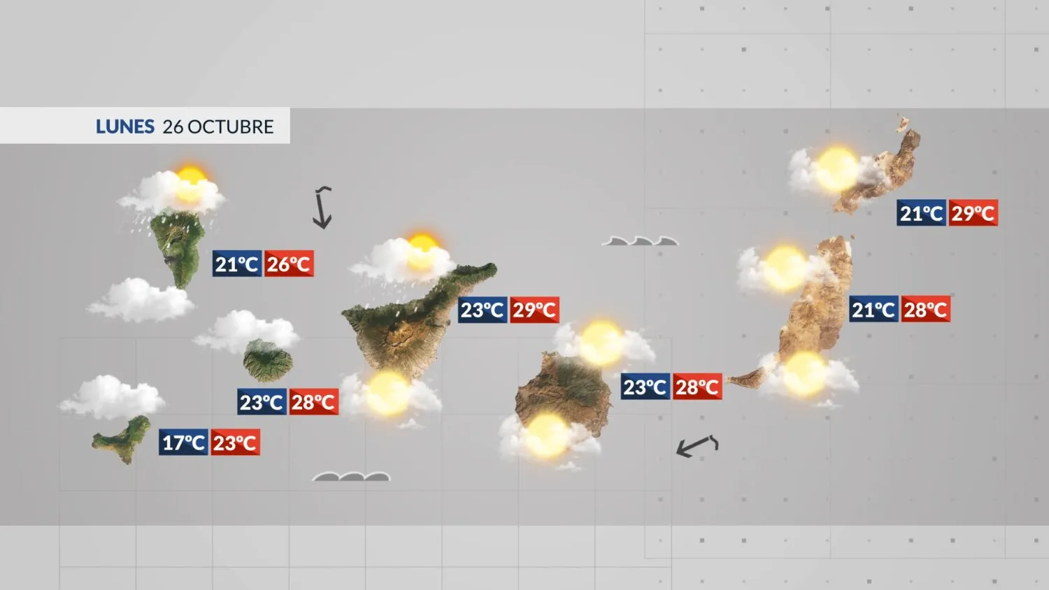
Compiled with the help of artificial intelligence, based on weather data. Source below the article.
The Canary Islands begin the week under a veil of Saharan dust and high cloud, with temperatures climbing sharply and the eastern islands feeling the heat most. Isolated showers and the odd storm are possible inland on the mountainous isles, while calima settles over mid-altitudes and summits on southern slopes.
General outlook
Mid and high cloud will dominate, with scattered and occasional showers likely in the interior of the mountainous islands. An isolated storm cannot be ruled out on the western isles. Calima will be at its thickest across mid-altitudes and summits on south-facing slopes.
Daytime temperatures are on the rise, particularly on the eastern islands. The mercury could hit 30–32C in the interior and southern half of La Gomera, Tenerife and Gran Canaria, while parts of inland and northern Fuerteventura and Lanzarote may see local readings of 34C.
Winds will be light and variable along the coasts of the western islands and Gran Canaria, with an easterly flow dominating further east. Over the highest summits, expect strong south-westerlies. Ocean swell from the north-northeast will bring waves of around 1.5 metres to the north coasts and the western shoreline of Fuerteventura and Lanzarote, with slightly choppy conditions along southern coasts.
Tenerife
Mid and high cloud with scattered, occasional showers, and the chance of an isolated storm in the higher interior. Calima in the upper air will be most intense in the south. Low cloud will linger in the north through the morning. Light, variable coastal winds. Temperatures could top 30C in the south and west, with Santa Cruz ranging from 23C to 29C.
Gran Canaria
Mid and high cloud with calima most pronounced across mid-altitudes and summits in the south. Some low cloud will drift into the north during the afternoon. An easterly wind in the morning will turn light and variable. Inland highs will exceed 30C, with 33C possible locally in the south and southeast. Las Palmas de Gran Canaria will see 23C to 28C.
Lanzarote
Scattered mid and high cloud will thicken to overcast. Calima will be most noticeable at altitude. Winds generally light and variable. Inland and western areas will pass 30C, with local highs of 34C. Arrecife will range from 21C to 29C.
Fuerteventura
Scattered mid and high cloud tending to overcast, with calima more intense in the upper air. Light, variable winds with an easterly bias. Inland and northern parts could reach 30–33C, with 34C locally. Puerto del Rosario will see 21C to 28C.
La Palma
Mid and high cloud with scattered, occasional showers and the chance of an isolated storm. Some low cloud is possible in the north at dawn. Calima will sit in the upper air. Light, variable coastal winds. Santa Cruz de La Palma will range from 21C to 26C.
La Gomera
Mid and high cloud with the odd weak, scattered shower and a possible isolated storm. Calima in the upper air, most significant in the south. Light, variable coastal winds. The south could reach 30C, while San Sebastián de La Gomera will see 23C to 28C.
El Hierro
Overcast with mid and high cloud and the chance of a stray drop of rain, along with an isolated storm. Calima will be more noticeable across mid-altitudes and summits in the south. Light, variable winds, moderate west-southwest over the summits. Coastal temperatures will be warmer.
La Graciosa
Scattered mid and high cloud with calima, most intense at altitude. Light, variable winds. Temperatures will pass 30C, with Caleta de Sebo ranging from 22C to 31C.