Güigüí is a beach you have to earn. You can’t drive here, you shouldn’t try to get here by boat, and you certainly won’t stumble upon it by accident. Three to four hours of hiking across rocky trails through arid barrancos — that’s the price of reaching one of the most beautiful and most isolated beaches in all of Europe. Black volcanic sand, sheer cliffs soaring hundreds of metres, and absolute silence — this is Güigüí.
The trail to Güigüí — what you need to know
The most popular trail starts in Tasartico — a tiny settlement on Gran Canaria’s west coast. From the car park at the end of the tarmac road, you head south through the Barranco de Tasartico gorge. The trail isn’t officially signposted, but the path is fairly clear. After about 2 hours you reach a mountain pass with your first view of the ocean — and the steep descent to the beach begins.
The total distance is roughly 8-10 km one way, with significant elevation changes. The terrain is dry, rocky, and completely without shade — in summer, temperatures exceed 35°C. The return via the same route means you need to set aside the entire day for this expedition. This is not a trail for beginners or anyone with fitness concerns.
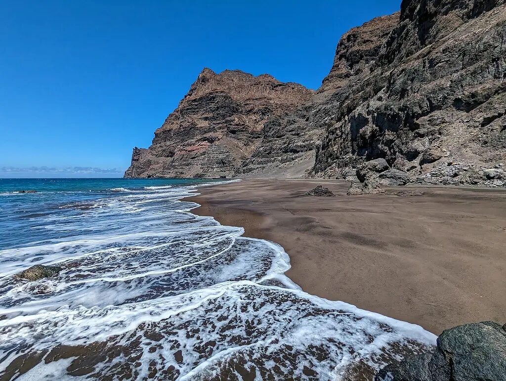
The beach itself — raw beauty
Güigüí is actually two beaches — Güigüí Grande and Güigüí Chico — separated by a rocky headland. The larger beach (Grande) is about 300 metres long and covered in dark volcanic sand mixed with pebbles. The cliffs surrounding the beach rise vertically for hundreds of metres, creating a setting that is simply breathtaking.
There is absolutely nothing on the beach — no facilities, no shade, no water source. The ocean here is open and powerful, with strong currents. Swimming is possible but demands caution — currents can be unpredictable. This is a beach for admiring, not for a typical day at the seaside.
How to prepare
Güigüí is an expedition, not a stroll. Set off early in the morning (ideally at dawn) to leave time for the return before dark. Bring at least 3 litres of water per person, food for the whole day, high-SPF sunscreen, a hat, and sturdy hiking boots — flip-flops are a recipe for disaster. A charged phone and offline maps (Google Maps/Mapy.cz) are essential, as mobile signal is weak or non-existent.
Practical information
- Beach length: approx. 300 m (Grande) + 100 m (Chico)
- Sand: dark volcanic, mixed with pebbles
- Getting there: on foot only — trail from Tasartico (3-4h one way)
- Facilities: none (zero amenities)
- Swimming: possible but with caution — strong currents
- Trail difficulty: high — good fitness and hiking boots required
- Phone signal: weak or none
Nearby beaches
Güigüí has no nearby beaches in the traditional sense — that’s precisely what makes it so special. The closest beach reachable by car is Playa de Tasarte, a few kilometres to the north, equally wild but far more accessible. To the south, on the other side of the mountains, lies Puerto de Mogán with its intimate harbour beach — a completely different world of comfort and gastronomy. It’s well worth combining both experiences in a single trip.